The Original Mountain Marathon, or OMM, is a two-day navigational challenge held at the end of October each year. It’s been going since 1968, when it was known as the KIMM (Karrimor International Mountain Marathon) and comprises three linear and three score events. Competitors enter as pairs and must be entirely self-sufficient for the two days, which means carrying a tent, sleeping bags, food, a stove, clothing, etc. so quite large packs.
I first heard about the OMM when I attended a mountain navigation course back in 2015. In fact, this was also when I first heard about orienteering and subsequently joined Mole Valley hoping to improve my navigation skills. It was another 8 years before I finally made it to the start line and rather ambitiously entered the “Long Score” category together with regular running buddy Mark Simpson. We’d both competed in the Great Lakeland 3 Day and the Saunders Lakeland Mountain Marathon as well as plenty of other running adventures and so weren’t completely out of our depth.
As the competition weekend was at the end of half-term, we planned a week’s family holiday up in Snowdonia and so had a couple of strenuous walks with the family in the days leading up to the event. My son was also desperate to go mountain biking on some rather extreme (for me) trails, so I was a bit worried about hurting myself before the OMM as I’m not nearly as good a rider as he is. Fortunately, I managed to stay the right way up and arrived unscathed on Saturday morning at Bethesda for the start.
Day 1
For day 1 we had a time limit of 7 hours and were hoping we’d manage somewhere between 30 and 35km but planned on seeing how far we’d gone after a couple of hours and using that as the basis for planning the remainder. At the start we looked at the map, swept out a broad circle that seemed to take in some high value controls and set off.
Here’s a portion of the map from day 1 with our route drawn in by hand:
Our first three controls (DO, BJ, AF) were easy enough although they seemed to be spaced further apart than I was expecting, at which point I realised that I’d been an idiot and somehow figured that on a 1:40k map 1cm=250m, which is silly in retrospect, my only plausible excuse is that I’d been hiking with OS 1:25k maps during the week plus 4 and 25 are reciprocals so there is some sort of logic in my faulty thinking. The maps also had elevation numbers removed so if using an altimeter you needed to read the altimeter at a known location, count the contours to where you wanted to be and then remember your target elevation. Sounds easy enough but somehow I was incapable of remembering a number for more than ten minutes and always seemed to end up guessing! Maybe scribbling measured values on the map would have been the smart solution; interested to hear what others do.
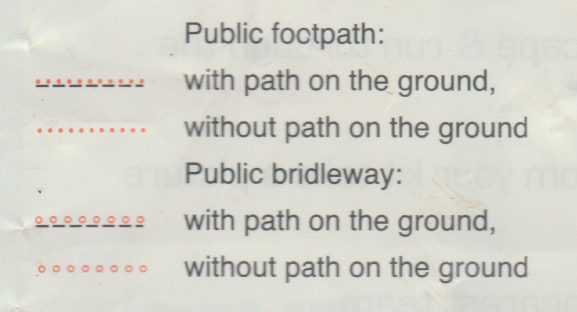
After that we did a lot of contouring round on grassy slopes to bag CI and DM, which was really hard work on the ankles and feet. After the 8th control (CN) we had what appeared to be a choice of some boggy ground for a 40 pointer (BK) or a path, marked by a dotted red line, that avoided that – we chose the path but failed to find it. Looking at the map key after the event I noticed this:
I’m guessing that’s why we never found it, but what exactly is a public footpath “without path on the ground”?
At our 10th control (DD) we bumped into Tim Scarbrough and Alex Kendall but after 5 minutes they were off into the distance and we only saw them again at the overnight camp.
A few kilometres later we crossed the A5 into more familiar territory around Tryfan and the Glyders. We’d originally planned to bag a few controls to the east of Tryfan but our legs were getting a bit tired and that now looked like a lot of extra climbing that could easily result in us exceeding the time limit, so we decided to follow a path parallel to the road past Tryfan and then south to a few controls dotted around some llyns before heading to the finish. Here’s where I made the first nav error, turning too soon on what looked like a path climbing up but which very soon became a much more difficult climb over a boulder field. We realised the error and headed west to get to the actual path and before long were back on track.
Our next few controls (CP, DH, BM) looked easy enough on the map but in reality there were a lot of contours to climb and descend between them so it was slow going. The descent from DH to the lake got as bit hairy at when we found ourselves trying to scramble down crags with Mark falling a bit, but fortunately not too far. We made it to the overnight camp with 10 minutes to spare so it seemed we’d made some good choices after all. We’d covered 29km, so almost the 30km we’d anticipated.
For day 1 we bagged 16 controls worth a total of 440 points putting us in 54th place.
Day 2
On the second day the time limit was only an hour less: 6 hours, so still a big day out.
We started off returning the way we’d come into the camp the day before to bag two controls, AU and CR, before crossing the A5 where we planned to follow the edge of the lake and then up Pen yr Ole Wen for a ridge run over Carnedd Fach and Carnedd Dafydd. This probably wasn’t the smartest route choice as it only bagged us a single 40 point control (DB), but in terms of running it was the highlight of the weekend!
After that a bit of contouring to BA and then down into the valley for DL, BO and DJ, followed by a climb up to CE, which on the map didn’t look that steep but it was hard work. Then a lovely downhill run to the river before bagging the final control BX. We briefly considered climbing to CF but decided not to as we were tired and would likely incur a penalty by missing the cut-off.
We bagged 11 controls worth a total of 370 points putting us in 106th place and a final position of 74th of 195 finishers. Day 2 felt like it had gone better than day 1 but we’d actually done worse! Total time for the two days was 12:23:42.
I really enjoyed the OMM. The weather made it tougher than both GL3D and the Saunders MM, and from what I hear this year was considered to be mild by OMM standards. I’m pretty sure I’ll be back next year in the Southern Highlands to see what proper OMM weather is like.
There were quite a few other pairs I know from both the Surrey Hills Running Club and Mole Valley Orienteering Club, here are all of our results:
| Tim Scarbrough & Alex Kendall | Long Score | 14th / 12th male |
| Mark Vyvyan-Robinson & Hasan Uctas | Long Score | 40th / 7th vet |
| Mark Simpson & John Pickup | Long Score | 74th / 57th male |
| Becky Raftery & Sarah Scarbrough | Long Score | 99th / 6th female |
| Barry Mcelearney & Keith Masson | B | 19th / 7th vet h/c |
| Robert McCaffrey & Simon Booth | B | 43rd / 23rd vet h/c |
| Philip Morgan & Rob Beale | B | 52nd / 25th vet h/c |


