Dorking Urban Orienteering

Although I’ve been orinteering for many years now I’ve never participated in an urban event before and so thought I’d give it a try.

Being new to urban events I didn’t really know what to expect but assumed it would be more difficult than Street O, requiring more careful examination of the map and had heard that checking for uncrossable boundaries was very important.

I’d volunteered to help at the start, and for the first shift was responsible for reading out instructions to those just about to start (“Have you read the safety notices? Have you cleared and checked? …”) having repeated that close to 100 times you would have thought it would have sunk in but somehow, I managed to get into the start box without putting my dibber in the check box. Fortunately, Rob McCaffrey asked me the same list of questions, so I realised and quickly headed back to be checked before the timer beeped.

Off to control 1, initially walking to have a proper look at the map, I couldn’t tell if it would be possible to make it to the control from the north side as it wasn’t clear if there was a gap between the OOB and the fence, but I decided to give it a go, running clockwise around the fenced area and that worked out fine.

Controls 2 and 3 were easy enough but control 4 needed a bit more thought as the obvious route was blocked with a black line but there was a way in via a passage to the north. Having got to the right location it wasn’t entirely obvious to me just what was at the middle of the control circle. This was a multi-level area in the shopping centre, so I ended up running around a bit searching but fortunately not for too long.

Controls 5 – 9 all had an obvious route, so by now I was feeling pretty confident.

Heading to control 10 I was again struggling to see exactly what was at the centre of the control circle and my knowledge of control descriptions wasn’t good enough to interpret the symbols:

Sarah Scarborough enlightened me after the event, and the way to read this is:
South-eastern Wall with the control at the north-west foot.
If I’d known that I wouldn’t have been on the wrong side of the fence, at the top instead of the bottom.

The remaining controls were all relatively straight-forward, apart from #15 where I was at the wrong side of the fence – the control description makes this clear if you bother to read it! After control 20 there were a couple of long legs that a fast runner could have made up lots of time, but I was struggling to go any faster than 10min/mile, so it felt like quite a long slog. After the long run to control 21 I was unreasonably annoyed by the black line blocking the obvious route to 22, but at 1:4000 the extra loop wasn’t all that far.

For the very final control I thought I had a good plan to minimise distance by heading west-north-west up a narrow road and then taking a diagonal through the field but was foiled by a hedge and ended up turning back. Whilst doing so I saw another running doing the same thing and thought “he’s in for a surprise”. After looping back, I came into the field along the path to the south of the control and imagine my surprise when I saw the same runner leaving the control before I’d even got there. It turned out that there was a gap in the hedge that is marked on the map if you look carefully enough.

I finished the event thinking I’d done reasonably well with only a few small mistakes, so was a bit disappointed to come 17th of 17. Better nav would have saved a few minutes but not more than ten, so looking at the results I suspect that my errors only cost me one place.

Discussing the event afterwards it was clear I needed to brush up on reading control descriptions. Here are some useful resources, which I’m sure will be useful for anyone else who needs to improve in this area:

https://www.maprunner.co.uk/iof-control-descriptions

https://www.octavian-droobers.org/index.php/coaching/on-line-quizzes/articles/294-map-symbol-training

I enjoyed my first go at urban orienteering and am sure I’ll be back for more. With Forest O I regularly make nav errors that cost me tens of minutes over the course and so can still believe that with improved nav skills one day I might do well, whereas with Urban the nav errors aren’t particularly significant so I’ll need to get much faster and I don’t think that’s going to happen!

Supporting a Puddle Buckley

A running friend, Mark Simpson, as well as being a great trail runner is also a swim-runner and wanted to complete the Puddle Buckley, which is the swim-run version of the Paddy Buckley. This is a 65km trail run taking in the majority of the Welsh 3000s plus swims across four lakes.

A swimmer I am not, but as a support runner I could run the route and, at each lake crossing, run around the lake carrying Mark’s running kit whilst he was swimming. This sounded like a great day out in the hills!

When completing a round you are free to choose any start point and run the route either clockwise or anticlockwise. Mark studied the route and decided it was missing a few summits that feature on the Paddy Buckley round and, never one to take the easy option, adjusted the route such that we could bag those too (five extras). We decided to start at Capel Curig and run the route anticlockwise meaning that we would get the difficult climbs done in the first half.

Leg 1 – Capel Curig to Llyn Ogwen

Up at 4am to cook some porridge for a 5am start. The weather forecast for the day was not looking good, with heavy rain starting at 8am that was set to continue the whole day.

Leaving the barn, we were welcomed with mainly blue skies and had a lovely run up the first summit, Pen Llithrig y Wrach (799m), one of Mark’s extras, during which we were rewarded with a gorgeous sunrise.

From the first summit we had great views over to the next, Pen Yr Helgi Du (833m), along the Bwlch y Tri Marchog ridge.

After clearing the next summit, the cloud started coming in and we heard a few unwelcome rumbles of thunder – not what you want on a day out in the mountains (or swimming across lakes)! The following summits of Carnedd Llewelyn (1,064m), Carnedd Dafydd (1,044m), Carnedd Fach (960m) and Pen yr Ole Wen (978m) were all familiar territory from the Welsh 3000s and last year’s OMM. It did start raining though and was cold enough to warrant pulling out the hat and gloves. No more views on this leg, just head down and keep moving.

We took the steep descent south off Pen yr Ole Wen to Llyn Ogwen, where Mark handed me his running kit and set off to swim across the lake. I walked around to meet him at the other side and could easily see him making progress across the lake.

The swim had left Mark a bit cold, so straight back on with his running kit to start leg 2…

Leg 2 – Llyn Ogwen to Llanberis

It didn’t take long to warm up on the stiff climb up Tryfan (918m), one of my favourite mountains in Snowdonia. It is a slow climb though, taking the best part of an hour. It was still cloudy on the top but it was no longer raining and there were some signs that it might start to clear. Coming off the top of Tryfan is always hard work, with too much clambering over rocks to make any speedy progress. Before long we were at the wall on the col and starting the next climb up Glyder Fach (994 m). This is mainly up a scree slope that’s very steep but once you reach the top it’s a relatively flat section bagging the remaining Glyders, Castell y Gwynt (972m) & Glyder Fawr (1,001m). The scenery up here is quite other-worldly, feeling like something out of Tolkien – it would be no surprise to stumble across a sleeping dragon.

A few more summits, Y Garn (947m), Foel-goch (831m), Elidir Fawr (924m) & Elidir Fach (721m) before the descent to Llanberis through the remains of the old slate mine.

Just before the shore of Llyn Padarn we stopped at a café for pies and coke. Mark then swam across the lake and I ran around to meet him at the other side. At this point I realised that having Mark’s route on my watch wasn’t brilliant as I’d assumed it would be easy to find my way around but ended up running up an old railway that was a cul-de-sac. Running is a lot faster than swimming though, so I made it to the other side before Mark had completed the swim.

Leg 3 – Llanberis to Llyn Gwynant

The next leg looked easy with just six summits, although one of them was Snowdon so still plenty of elevation. The weather had improved greatly during leg 2 and we were now back to blue skies and sun but we were both low on water. We didn’t much want to spend money buying bottled water and so, running through the town, were on the lookout for a tap. We didn’t spot one but did come across a runner who was waiting outside his mate’s house, so it was easy to ask a fellow runner if we could top up our bottles.  

The climb up Moel Eilio (726m) was a nice grassy slope and then over Foel Gron (629m) and Moel Cynghorion (674m) without too much loss of elevation. From here it initially looked like we were going to contour round to the Snowdon Mountain railway but in fact we dropped right back down to 400m before starting the climb up Snowdon (1,085m) bagging Clogwyn Llechwedd-Llo (600 m) and Bwlch Glâs (998m) on the way.

A very brief stop at the top to dodge the crowds and touch the summit cairn before starting the descent down to Llyn Gwynant. At this stage our ETA at the finish was after 11pm but we were hopeful a few miles of downhill would pull that in so we’d be able to finish with a pint.

Mark’s swim across Llyn Gwynant was another where I’d wished I planned ahead as there was no lakeside path and I needed to head a fair way up the river at the end before finding a bridge to cross. Mark managed to complete the swim before I’d made it round to the exit point.

Leg 4 – Llyn Gwynant to Capel Curig

The final leg looked easy on paper with just three summits and not too much dropping down between them. The day’s climbing was taking its toll though, and progress wasn’t as quick as it should have been. We managed the three summits, Carnedd y Cribau (591m), Clogwyn Bwlch-y-maen (548m) and Moel Siabod (872m) before dark, rewarded with a fantastic sunset on the last climb.

It looked like it was in the bag now, with just an easy descent to the lake, a final swim, and another mile on the flat before we’d be back at the start.

As darkness fell, we stopped to get out our headtorches and almost immediately realised we’d gone off the route, continuing down a path that we shouldn’t be on. There was no sign of a path to follow so we struck out on a bearing to make it down to the lake. The going got tough though will some difficult rocky and heathery bits that we had to slide down.

On reaching the lake side there was no sign of Mark. After a bit of shouting in the dark we located each other. He’d descended to a cliff at the side of the lake but we managed to find a beach that he could swim from. The only problem now was that it was pitch dark with no visible references for Mark to swim to, so I needed to get around the lake to give him something to sight on. There were no paths and a rather grotty forest, so once again it would have been a benefit to have planned my route beforehand. Mark was understandably quite worried about swimming across a lake with no visibility, so I got a move on to make it round as quickly as I could and fortunately managed to find a forestry track that brought me out at a bridge that got me to the other side.

After locating the exit point I sat on a rock and put my headtorch into flash mode to give Mark something obvious to look for but realised fairly quickly that it was signalling … — … , which really wasn’t ideal as I didn’t need rescuing, so I just switched it back to regular always-on mode and looked out at the red dot that was Mark’s headtorch underneath his swimcap. The moon was out so it was yet another beautiful view.

Before long Mark had made it across the lake but was very cold so we got moving as quickly as possible for the final bit of run along the road to Capel Curig, where we finished just after midnight, with an elapsed time of 19:03:09. The route, for me, ended up being 72.7km with 5600m of elevation, so a tiny bit less if you were swimming the lakes.

All-in-all a fantastic adventure. Looking forward to more of the same on the Frog Graham next year!

The OMM 2023 – Snowdonia

The Original Mountain Marathon, or OMM, is a two-day navigational challenge held at the end of October each year. It’s been going since 1968, when it was known as the KIMM (Karrimor International Mountain Marathon) and comprises three linear and three score events. Competitors enter as pairs and must be entirely self-sufficient for the two days, which means carrying a tent, sleeping bags, food, a stove, clothing, etc. so quite large packs.

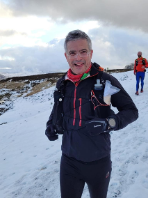
I first heard about the OMM when I attended a mountain navigation course back in 2015. In fact, this was also when I first heard about orienteering and subsequently joined Mole Valley hoping to improve my navigation skills. It was another 8 years before I finally made it to the start line and rather ambitiously entered the “Long Score” category together with regular running buddy Mark Simpson.  We’d both competed in the Great Lakeland 3 Day and the Saunders Lakeland Mountain Marathon as well as plenty of other running adventures and so weren’t completely out of our depth.

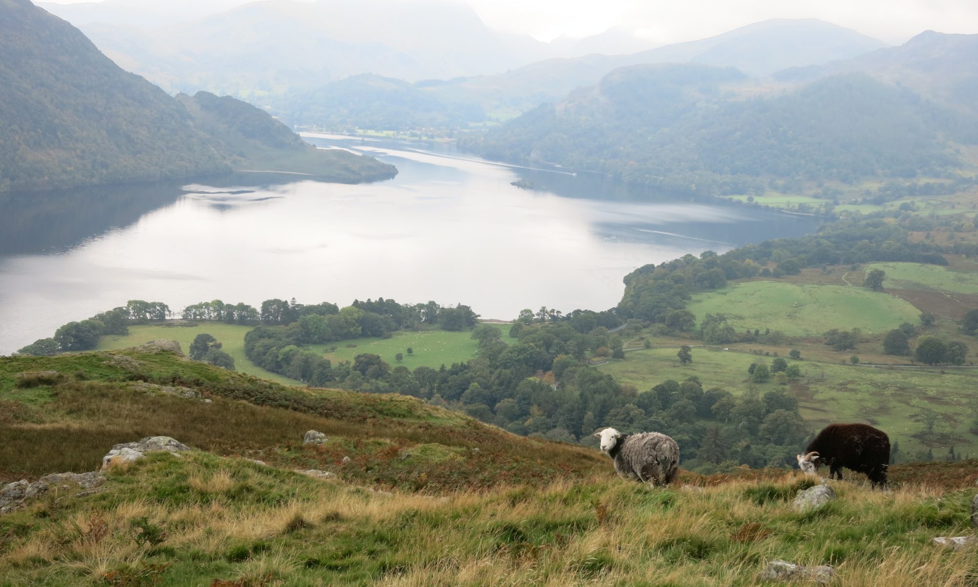
As the competition weekend was at the end of half-term, we planned a week’s family holiday up in Snowdonia and so had a couple of strenuous walks with the family in the days leading up to the event. My son was also desperate to go mountain biking on some rather extreme (for me) trails, so I was a bit worried about hurting myself before the OMM as I’m not nearly as good a rider as he is. Fortunately, I managed to stay the right way up and arrived unscathed on Saturday morning at Bethesda for the start.

Day 1

For day 1 we had a time limit of 7 hours and were hoping we’d manage somewhere between 30 and 35km but planned on seeing how far we’d gone after a couple of hours and using that as the basis for planning the remainder. At the start we looked at the map, swept out a broad circle that seemed to take in some high value controls and set off.

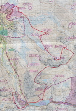
Here’s a portion of the map from day 1 with our route drawn in by hand:

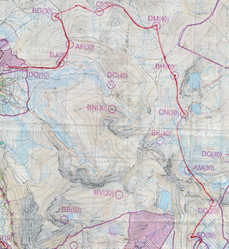
Our first three controls (DO, BJ, AF) were easy enough although they seemed to be spaced further apart than I was expecting, at which point I realised that I’d been an idiot and somehow figured that on a 1:40k map 1cm=250m, which is silly in retrospect, my only plausible excuse is that I’d been hiking with OS 1:25k maps during the week plus 4 and 25 are reciprocals so there is some sort of logic in my faulty thinking. The maps also had elevation numbers removed so if using an altimeter you needed to read the altimeter at a known location, count the contours to where you wanted to be and then remember your target elevation. Sounds easy enough but somehow I was incapable of remembering a number for more than ten minutes and always seemed to end up guessing! Maybe scribbling measured values on the map would have been the smart solution; interested to hear what others do.

After that we did a lot of contouring round on grassy slopes to bag CI and DM, which was really hard work on the ankles and feet. After the 8th control (CN) we had what appeared to be a choice of some boggy ground for a 40 pointer (BK) or a path, marked by a dotted red line, that avoided that – we chose the path but failed to find it.  Looking at the map key after the event I noticed this:

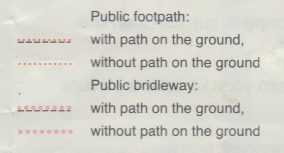
I’m guessing that’s why we never found it, but what exactly is a public footpath “without path on the ground”?

At our 10th control (DD) we bumped into Tim Scarbrough and Alex Kendall but after 5 minutes they were off into the distance and we only saw them again at the overnight camp.

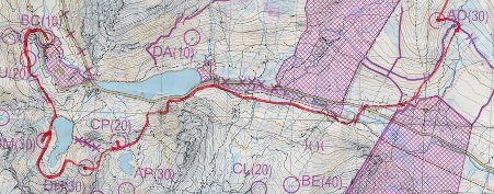
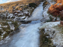
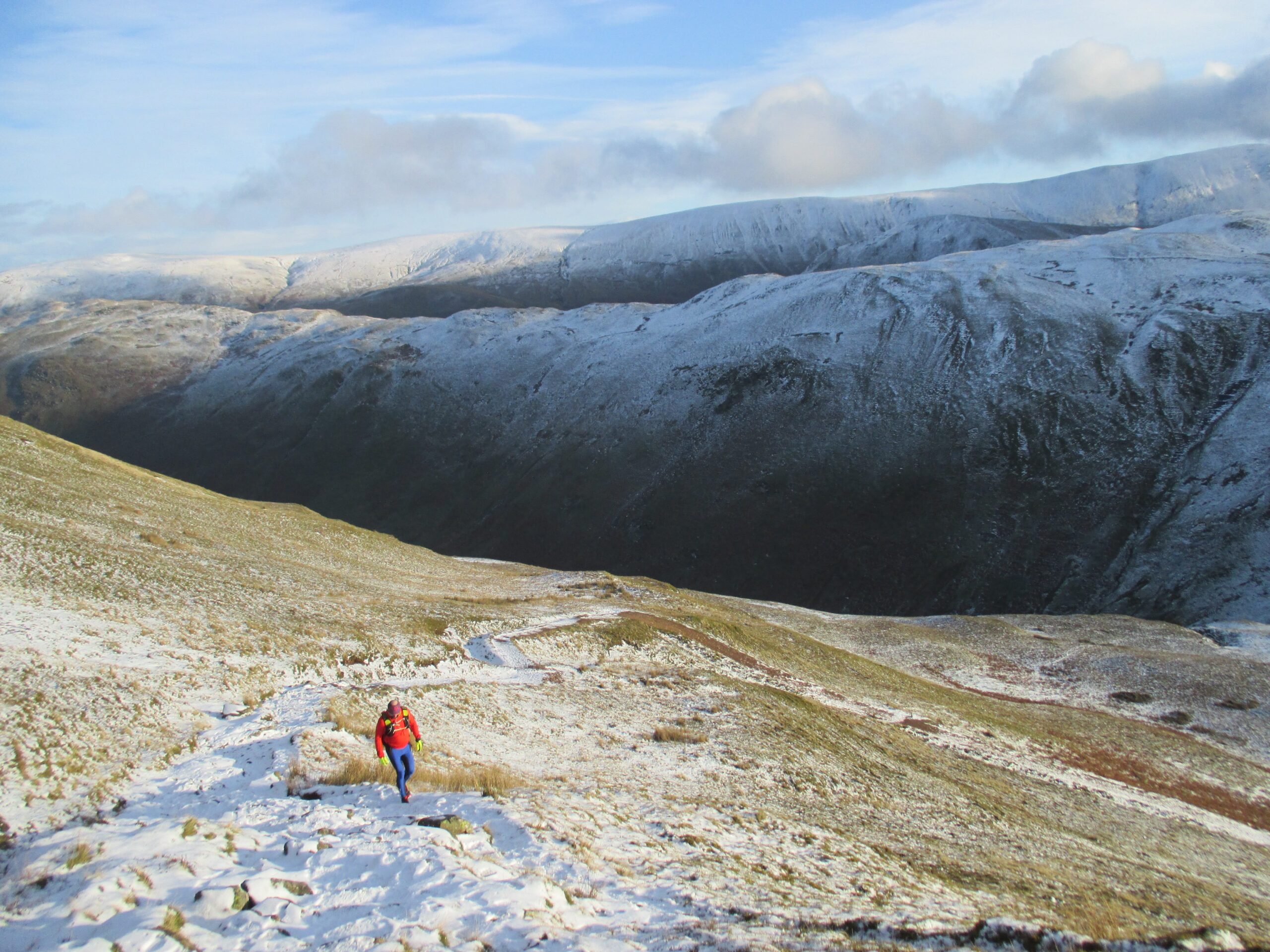
A few kilometres later we crossed the A5 into more familiar territory around Tryfan and the Glyders. We’d originally planned to bag a few controls to the east of Tryfan but our legs were getting a bit tired and that now looked like a lot of extra climbing that could easily result in us exceeding the time limit, so we decided to follow a path parallel to the road past Tryfan and then south to a few controls dotted around some llyns before heading to the finish. Here’s where I made the first nav error, turning too soon on what looked like a path climbing up but which very soon became a much more difficult climb over a boulder field. We realised the error and headed west to get to the actual path and before long were back on track.

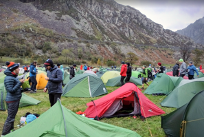
Our next few controls (CP, DH, BM) looked easy enough on the map but in reality there were a lot of contours to climb and descend between them so it was slow going. The descent from DH to the lake got as bit hairy at when we found ourselves trying to scramble down crags with Mark falling a bit, but fortunately not too far. We made it to the overnight camp with 10 minutes to spare so it seemed we’d made some good choices after all. We’d covered 29km, so almost the 30km we’d anticipated.

For day 1 we bagged 16 controls worth a total of 440 points putting us in 54th place.

Day 2

On the second day the time limit was only an hour less: 6 hours, so still a big day out.

We started off returning the way we’d come into the camp the day before to bag two controls, AU and CR, before crossing the A5 where we planned to follow the edge of the lake and then up Pen yr Ole Wen for a ridge run over Carnedd Fach and Carnedd Dafydd. This probably wasn’t the smartest route choice as it only bagged us a single 40 point control (DB), but in terms of running it was the highlight of the weekend!

After that a bit of contouring to BA and then down into the valley for DL, BO and DJ, followed by a climb up to CE, which on the map didn’t look that steep but it was hard work. Then a lovely downhill run to the river before bagging the final control BX. We briefly considered climbing to CF but decided not to as we were tired and would likely incur a penalty by missing the cut-off.

We bagged 11 controls worth a total of 370 points putting us in 106th place and a final position of 74th of 195 finishers. Day 2 felt like it had gone better than day 1 but we’d actually done worse! Total time for the two days was 12:23:42.

I really enjoyed the OMM. The weather made it tougher than both GL3D and the Saunders MM, and from what I hear this year was considered to be mild by OMM standards. I’m pretty sure I’ll be back next year in the Southern Highlands to see what proper OMM weather is like.

There were quite a few other pairs I know from both the Surrey Hills Running Club and Mole Valley Orienteering Club, here are all of our results:

Tim Scarbrough & Alex Kendall         Long Score14th / 12th male
Mark Vyvyan-Robinson & Hasan UctasLong Score40th / 7th vet
Mark Simpson & John PickupLong Score74th / 57th male          
Becky Raftery & Sarah ScarbroughLong Score99th / 6th female
Barry Mcelearney & Keith MassonB19th / 7th vet h/c
Robert McCaffrey & Simon BoothB43rd / 23rd vet h/c
Philip Morgan & Rob BealeB52nd / 25th vet h/c

Tour de Helvellyn

The Tour de Helvellyn takes place every year on the Saturday closest to the winter solstice. It’s a 39 mile race that goes around rather than over Helvellyn. There is no set route, just a series of seven checkpoints that you need to visit. Here’s how it looks on a 1:25k OS map with the checkpoints marked:

Sitting in the pub the evening before the race, we were notified that ice meant that the event would be shortened this year and would be an out-and-back to checkpoint 3, missing out Sticks Pass, the western side of Helvellyn along Thirlmere and the return past Grisedale Tarn. This was quite disappointing to hear as that meant the best parts of the route were going to be missed. The event was also going to start an hour later, so that plus the disappointment lead to far too many pints in the pub that night and I was rewarded with a headache the following morning – not the best race prep!

Setting off over Askham Fell there were some excellent sections of running through snow, something that I always enjoy.

Descending a bit, it soon became clear why the route had been shortened as in areas where over the previous week there had been repeated freezing and thawing the paths had become sheets of ice that were impossible to run on; the only way to safely make progress was to run off-trail until the icy sections were over.

Bar these icy bits the route was easy to the first checkpoint at Martindale Church and then followed an uninspiring stretch mainly on road up Boredale (an apt name it seems). The fells on either side looked amazing in the snow and an idea took hold that it might be worth taking a different route on the way back to bag a couple of Wainwrights and enjoy the snow higher up. At this point I was running with Mark, who I regularly train with in the Surrey Hills, and it sounded like he might be up for a diversion too. No need to decide now as we’d get a better idea of conditions higher up after reaching the turnaround point on the way up Sticks Pass.

In to checkpoint 2, at which stage some of the faster runners started flying past, Damian Hall, Paul Tierney, …, one chap who I didn’t recognise didn’t even slow down for a cattle grid and leapt all the way over in a single stride. At the time I remember thinking “that could have gone spectacularly wrong!”

A bit more road to Glenridding and then up past the Youth Hostel to start the climb up Sticks Pass. Not to the top though as we would be turned back at checkpoint 3 about halfway up. Whilst still on the way up we got to see the fast runners a second time as they came hurtling back down.

Reaching checkpoint 3, at a little over 13 miles, we still felt fresh and conditions didn’t seem that bad, so we were definitely up for more of a challenge and thus the more interesting return route was on the cards. The best option looked to be to head north at Boredale Hause to take in Round How and Place Fell. It did feel a bit weird deliberately heading off the route that everyone else was taking, but this is a self-navigation event with no set route so, apart from being a slow option, this was completely valid as it still visited all the checkpoints.

Once up on the tops the decision proved sound, with loads of snow, great views and the trail to ourselves.

We rejoined the standard route just before the final checkpoint at Martindale Church and then an easy run over Askham Fell took to us to the finish for a bowl of Joe’s legendary soup.

All-in-all a cracking day out on the winter fells, even if it wasn’t the full route. I’ll be back again for sure and can certainly recommend this event as an antidote to the stresses of Christmas shopping.