The Original Mountain Marathon, or OMM, is a two-day navigational challenge held at the end of October each year. It’s been going since 1968, when it was known as the KIMM (Karrimor International Mountain Marathon) and comprises three linear and three score events. Competitors enter as pairs and must be entirely self-sufficient for the two days, which means carrying a tent, sleeping bags, food, a stove, clothing, etc. so quite large packs.
I first heard about the OMM when I attended a mountain navigation course back in 2015. In fact, this was also when I first heard about orienteering and subsequently joined Mole Valley hoping to improve my navigation skills. It was another 8 years before I finally made it to the start line and rather ambitiously entered the “Long Score” category together with regular running buddy Mark Simpson. We’d both competed in the Great Lakeland 3 Day and the Saunders Lakeland Mountain Marathon as well as plenty of other running adventures and so weren’t completely out of our depth.
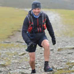
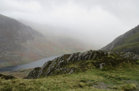
As the competition weekend was at the end of half-term, we planned a week’s family holiday up in Snowdonia and so had a couple of strenuous walks with the family in the days leading up to the event. My son was also desperate to go mountain biking on some rather extreme (for me) trails, so I was a bit worried about hurting myself before the OMM as I’m not nearly as good a rider as he is. Fortunately, I managed to stay the right way up and arrived unscathed on Saturday morning at Bethesda for the start.
Day 1
For day 1 we had a time limit of 7 hours and were hoping we’d manage somewhere between 30 and 35km but planned on seeing how far we’d gone after a couple of hours and using that as the basis for planning the remainder. At the start we looked at the map, swept out a broad circle that seemed to take in some high value controls and set off.
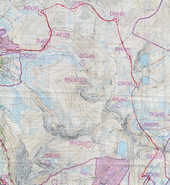
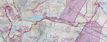
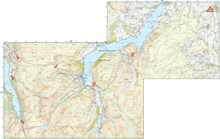
Here’s a portion of the map from day 1 with our route drawn in by hand:
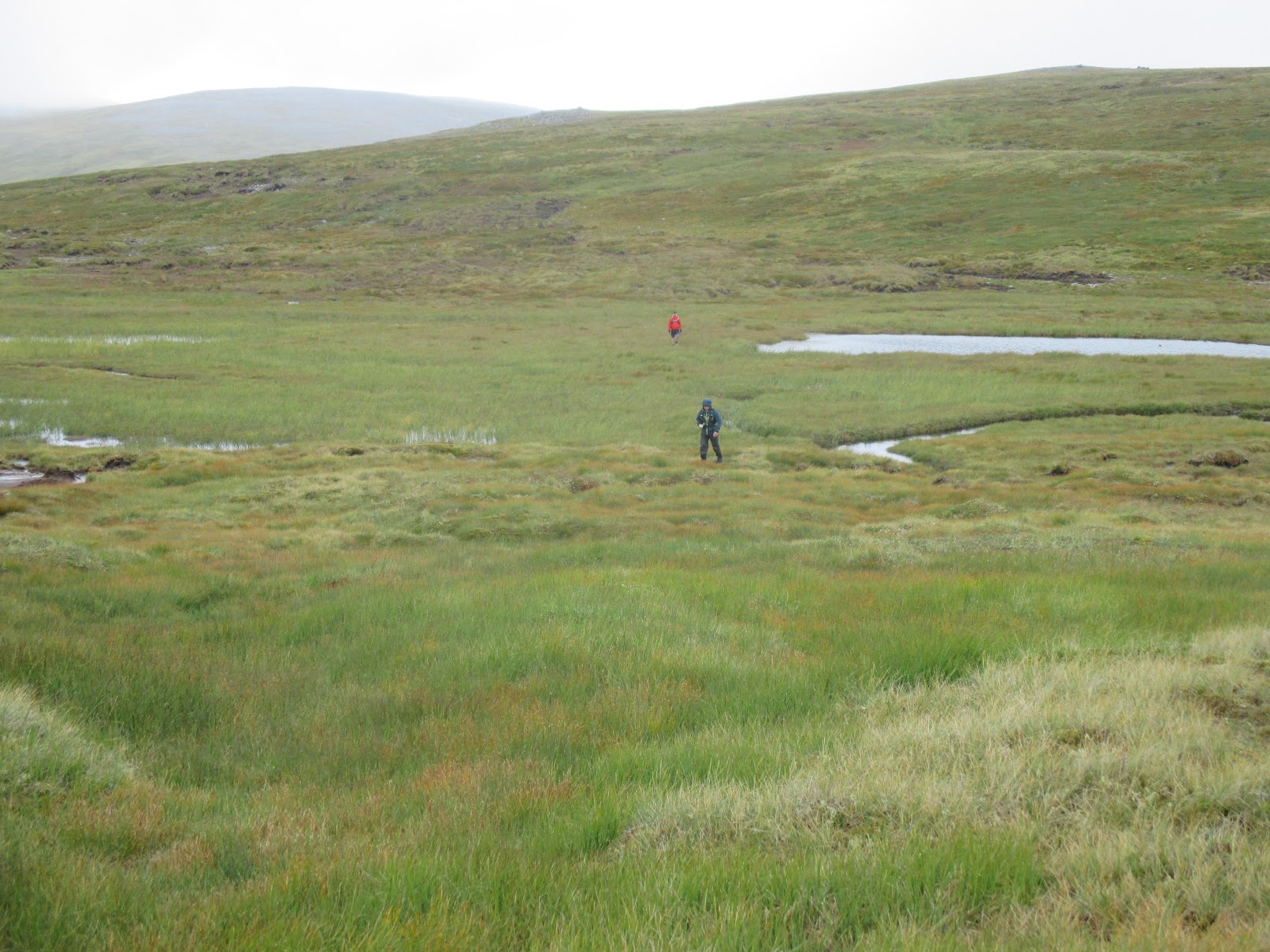
Our first three controls (DO, BJ, AF) were easy enough although they seemed to be spaced further apart than I was expecting, at which point I realised that I’d been an idiot and somehow figured that on a 1:40k map 1cm=250m, which is silly in retrospect, my only plausible excuse is that I’d been hiking with OS 1:25k maps during the week plus 4 and 25 are reciprocals so there is some sort of logic in my faulty thinking. The maps also had elevation numbers removed so if using an altimeter you needed to read the altimeter at a known location, count the contours to where you wanted to be and then remember your target elevation. Sounds easy enough but somehow I was incapable of remembering a number for more than ten minutes and always seemed to end up guessing! Maybe scribbling measured values on the map would have been the smart solution; interested to hear what others do.
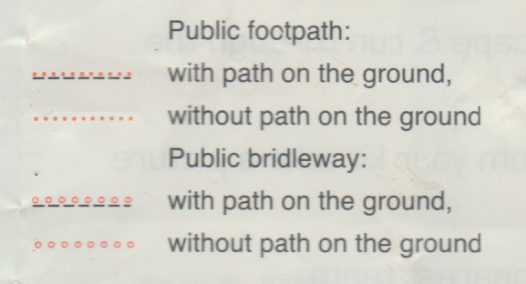
After that we did a lot of contouring round on grassy slopes to bag CI and DM, which was really hard work on the ankles and feet. After the 8th control (CN) we had what appeared to be a choice of some boggy ground for a 40 pointer (BK) or a path, marked by a dotted red line, that avoided that – we chose the path but failed to find it. Looking at the map key after the event I noticed this:
I’m guessing that’s why we never found it, but what exactly is a public footpath “without path on the ground”?
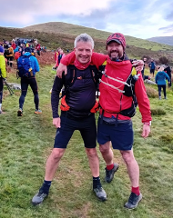
At our 10th control (DD) we bumped into Tim Scarbrough and Alex Kendall but after 5 minutes they were off into the distance and we only saw them again at the overnight camp.
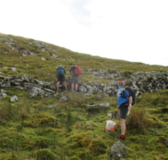
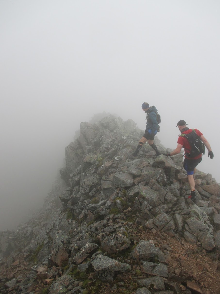
A few kilometres later we crossed the A5 into more familiar territory around Tryfan and the Glyders. We’d originally planned to bag a few controls to the east of Tryfan but our legs were getting a bit tired and that now looked like a lot of extra climbing that could easily result in us exceeding the time limit, so we decided to follow a path parallel to the road past Tryfan and then south to a few controls dotted around some llyns before heading to the finish. Here’s where I made the first nav error, turning too soon on what looked like a path climbing up but which very soon became a much more difficult climb over a boulder field. We realised the error and headed west to get to the actual path and before long were back on track.
Our next few controls (CP, DH, BM) looked easy enough on the map but in reality there were a lot of contours to climb and descend between them so it was slow going. The descent from DH to the lake got as bit hairy at when we found ourselves trying to scramble down crags with Mark falling a bit, but fortunately not too far. We made it to the overnight camp with 10 minutes to spare so it seemed we’d made some good choices after all. We’d covered 29km, so almost the 30km we’d anticipated.
For day 1 we bagged 16 controls worth a total of 440 points putting us in 54th place.
Day 2
On the second day the time limit was only an hour less: 6 hours, so still a big day out.
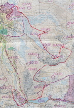
We started off returning the way we’d come into the camp the day before to bag two controls, AU and CR, before crossing the A5 where we planned to follow the edge of the lake and then up Pen yr Ole Wen for a ridge run over Carnedd Fach and Carnedd Dafydd. This probably wasn’t the smartest route choice as it only bagged us a single 40 point control (DB), but in terms of running it was the highlight of the weekend!
After that a bit of contouring to BA and then down into the valley for DL, BO and DJ, followed by a climb up to CE, which on the map didn’t look that steep but it was hard work. Then a lovely downhill run to the river before bagging the final control BX. We briefly considered climbing to CF but decided not to as we were tired and would likely incur a penalty by missing the cut-off.
We bagged 11 controls worth a total of 370 points putting us in 106th place and a final position of 74th of 195 finishers. Day 2 felt like it had gone better than day 1 but we’d actually done worse! Total time for the two days was 12:23:42.
I really enjoyed the OMM. The weather made it tougher than both GL3D and the Saunders MM, and from what I hear this year was considered to be mild by OMM standards. I’m pretty sure I’ll be back next year in the Southern Highlands to see what proper OMM weather is like.
There were quite a few other pairs I know from both the Surrey Hills Running Club and Mole Valley Orienteering Club, here are all of our results:
The Tour de Helvellyn takes place every year on the Saturday closest to the winter solstice. It’s a 39 mile race that goes around rather than over Helvellyn. There is no set route, just a series of seven checkpoints that you need to visit. Here’s how it looks on a 1:25k OS map with the checkpoints marked:
Sitting in the pub the evening before the race, we were notified that ice meant that the event would be shortened this year and would be an out-and-back to checkpoint 3, missing out Sticks Pass, the western side of Helvellyn along Thirlmere and the return past Grisedale Tarn. This was quite disappointing to hear as that meant the best parts of the route were going to be missed. The event was also going to start an hour later, so that plus the disappointment lead to far too many pints in the pub that night and I was rewarded with a headache the following morning – not the best race prep!
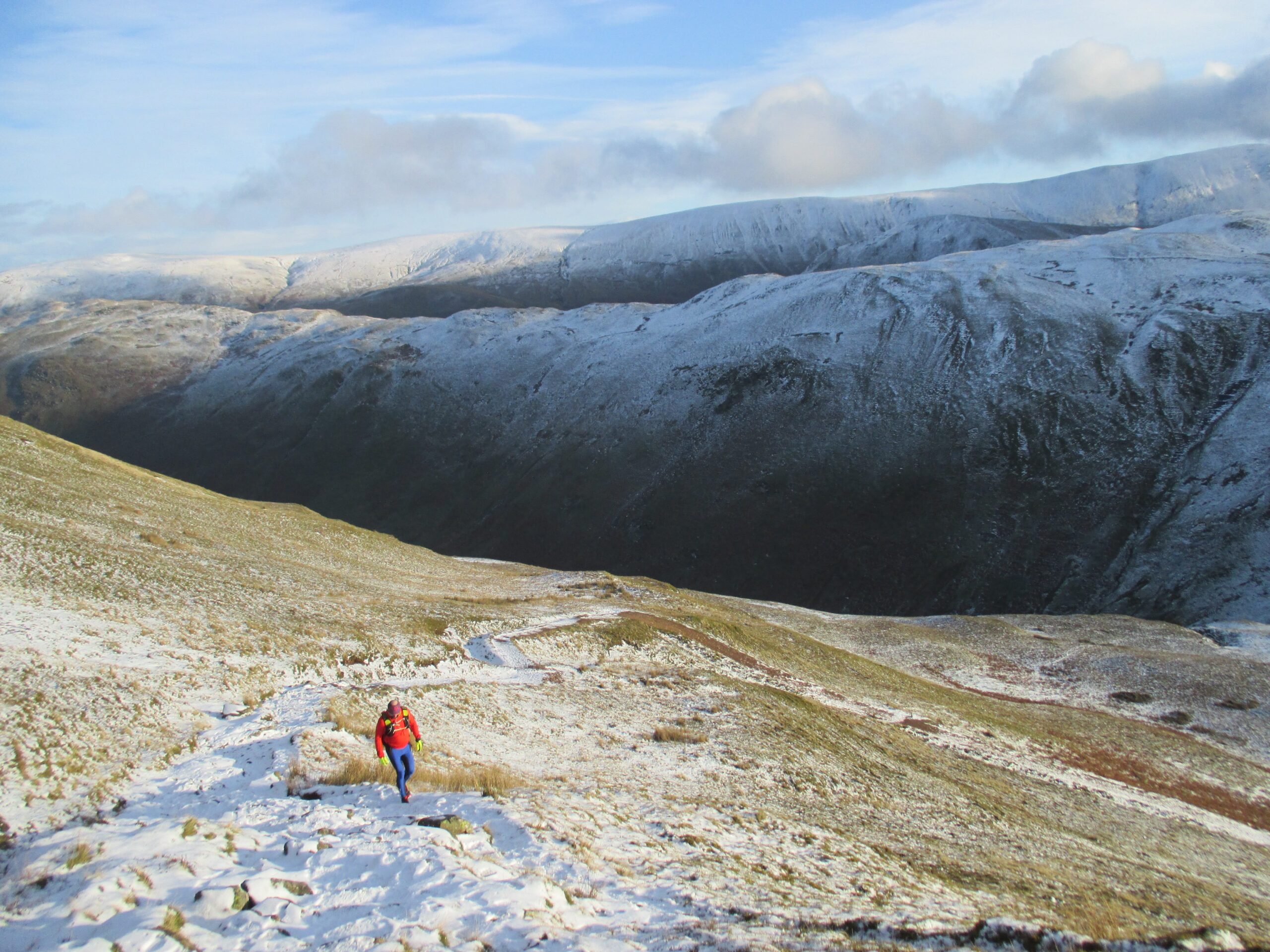
Setting off over Askham Fell there were some excellent sections of running through snow, something that I always enjoy.
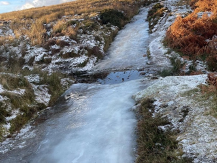
Descending a bit, it soon became clear why the route had been shortened as in areas where over the previous week there had been repeated freezing and thawing the paths had become sheets of ice that were impossible to run on; the only way to safely make progress was to run off-trail until the icy sections were over.
Bar these icy bits the route was easy to the first checkpoint at Martindale Church and then followed an uninspiring stretch mainly on road up Boredale (an apt name it seems). The fells on either side looked amazing in the snow and an idea took hold that it might be worth taking a different route on the way back to bag a couple of Wainwrights and enjoy the snow higher up. At this point I was running with Mark, who I regularly train with in the Surrey Hills, and it sounded like he might be up for a diversion too. No need to decide now as we’d get a better idea of conditions higher up after reaching the turnaround point on the way up Sticks Pass.
In to checkpoint 2, at which stage some of the faster runners started flying past, Damian Hall, Paul Tierney, …, one chap who I didn’t recognise didn’t even slow down for a cattle grid and leapt all the way over in a single stride. At the time I remember thinking “that could have gone spectacularly wrong!”
A bit more road to Glenridding and then up past the Youth Hostel to start the climb up Sticks Pass. Not to the top though as we would be turned back at checkpoint 3 about halfway up. Whilst still on the way up we got to see the fast runners a second time as they came hurtling back down.
Reaching checkpoint 3, at a little over 13 miles, we still felt fresh and conditions didn’t seem that bad, so we were definitely up for more of a challenge and thus the more interesting return route was on the cards. The best option looked to be to head north at Boredale Hause to take in Round How and Place Fell. It did feel a bit weird deliberately heading off the route that everyone else was taking, but this is a self-navigation event with no set route so, apart from being a slow option, this was completely valid as it still visited all the checkpoints.
Once up on the tops the decision proved sound, with loads of snow, great views and the trail to ourselves.
We rejoined the standard route just before the final checkpoint at Martindale Church and then an easy run over Askham Fell took to us to the finish for a bowl of Joe’s legendary soup.
All-in-all a cracking day out on the winter fells, even if it wasn’t the full route. I’ll be back again for sure and can certainly recommend this event as an antidote to the stresses of Christmas shopping.
After a successful outing for the Surrey Hills Running Club at the Welsh 3000s in 2020 it was decided that a tougher challenge was in order and the Scottish 4000s sounded like a logical next step for 2021.
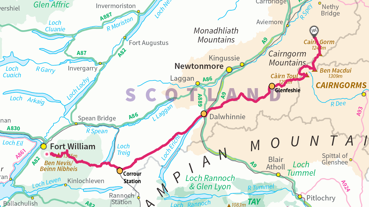
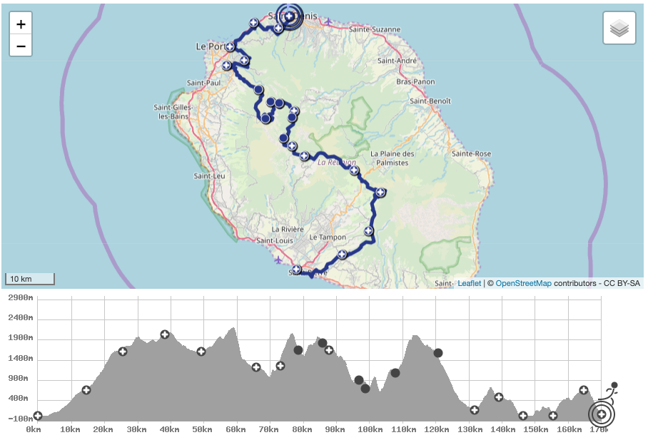
The Scottish 4000-foot summits are on two different mountain ranges, the Lochaber range near Fort William, including Ben Nevis, and the Cairngorms near Aviemore with about 80km of very remote terrain between them and few opportunities to resupply and even fewer to drop out. This was going to be a much bigger undertaking than the Welsh trip.
Mark started researching the route and plotted a rough draft on OS maps coming in at 140km with 5700m of climbing. The route would start at Fort William and finish at the Cairngorm youth hostel. The only road crossing on the route would be at Dalwhinnie, roughly half way. This was a long way to go self-supported. Mark found two further support points: Corrour Station at 34km with a restaurant and Glenfeshie at 100km where we could setup a tent containing supplies. This split the final route into four roughly equal sections.
ID
Description
Distance (km)
Elevation (m)
Start
Fort William
0
40
P1
Ben Nevis
7
1345
P2
Carn Mor Dearg
9
1220
P3
Aonach Mor
11.6
1221
P4
Aonach Beag
13.4
1234
B1
Stob Coire Bealach (bonus Munro)
14.4
1048
CP1
Corrour Station
34.8
400
CP2
Dalwhinnie
71.4
350
CP3
Glenfeshy
102
350
P5
Cairn Toul
117
1291
P6
Sgor an Lochain Uaine (The Angel’s Peak)
118
1258
P7
Carn na Criche
120
1265
P8
Braeriach
122
1296
P9
Ben Macdui
127
1309
P10
Cairn Gorm
133
1244
End
Cairn Gorm Lodge
140
330
Accommodation was booked at the Cairngorm Youth Hostel for four nights giving us a little bit of flexibility for the start in case of bad weather. The plan was then to drive to Fort William and run back to the hostel. We would need at least two cars so that we could subsequently drive back to Fort William to collect the car we’d left there.
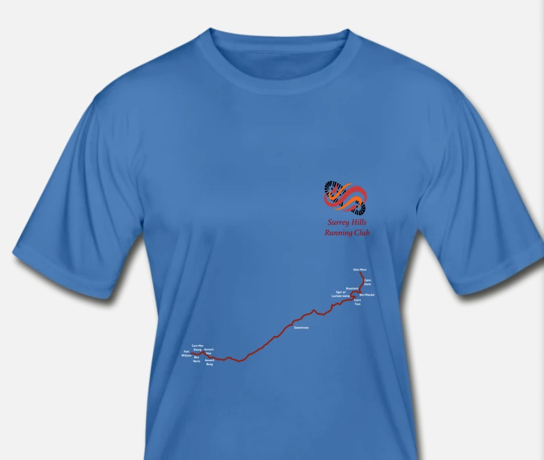
Next, we got some T-shirts printed as this was shaping up to be a big challenge that needed some kind of memento.
Setup prior to embarking on the route wasn’t straightforward. We needed to find somewhere to leave resupply points at Dalwhinnie and Glenfeshie. Dalwhinnie was quite easy – we spoke to a restaurant, The Snack Shack, and asked if we could leave of box of supplies in case we didn’t make it before closing and that was all OK. Glenfeshie was a bit more complicated as there are no roads so we had a 10km hike the day before to setup a tent hidden a little way off the trail. That took a couple of hours but did loosen up the legs a bit after the long drive up to Scotland.
Fort William to Corrour Station
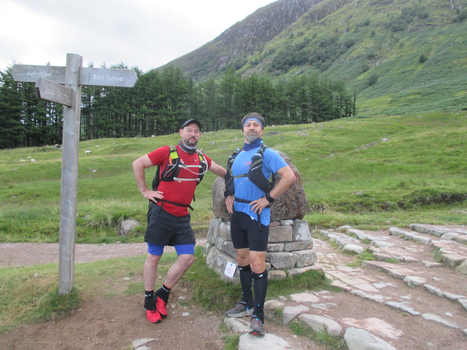
An early alarm woke us at 4am for the drive to Fort William. Boil water for porridge and a quick coffee and then we were off, arriving at Fort William a little after 6am. By 6:30 we were on the trail with a target to finish in 35 hours.
Let’s go!
The initial climb was up the tourist track to the summit of Ben Nevis. Although this was almost 4000′ of climb it was easy going. The trail was busy with lots of groups taking part in Three Peaks challenges. We reached the summit after almost exactly 2 hours, having covered 7km. The summit was also very busy so we didn’t spend any time there and just pressed on to the next section.
The area around the summit was shattered rock, much like the summit of Scafell Pike so there wasn’t a distinct path to follow and visibility was low so we just followed a bearing and soon came to an exciting ridge similar to Crib Goch. There was quite a strong wind from the south east so it wasn’t much fun on the ridge itself but there was a path a little way down on the right that felt a lot more secure.
The ridge to Carn Mor Dearg
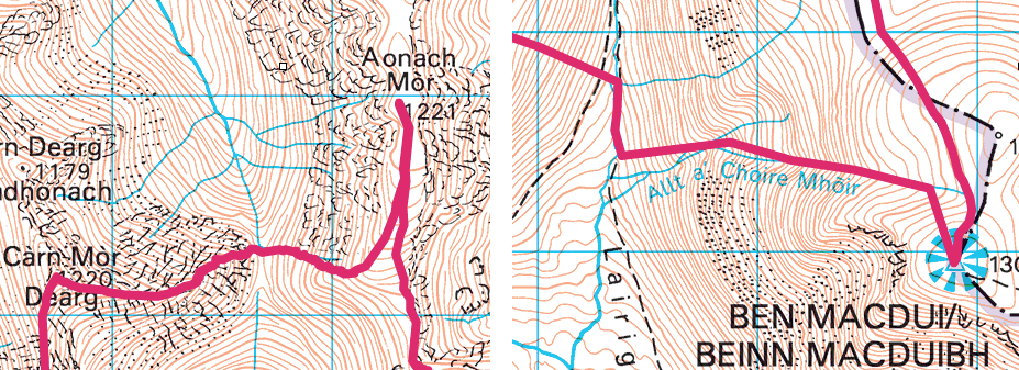
The ridge took us to Carn Mor Dearg, the second 4000′ summit only 2km after Ben Nevis but taking 1h15. Next was a steep descent and ascent, each 400m, to get up to Aonach Mor. Looking across the climb appeared quite intimidating but ultimately wasn’t too hard and it was a relief to make the next summit feeling strong as this looked to be similar to the steep climb we’d face in the Cairngorms up Ben Macdui much later, so we were now confident that wouldn’t be too much harder, of course by then we’d not nearly be so fresh and, looking at the map now, Ben Macdui is clearly a much bigger climb but in our heads we’d proved ourselves capable of the challenge.
Aoonach Mor vs Ben Macdui
Next was a relatively easy section across the tops to take in Aonach Beag and Stob Coire Bhealaich before descending to the river that would take us to Loch Trieg and Corrour Station.
The planned descent off Bhealaich appeared way too steep, heading straight off a buttress, so we headed a little further south to find an easier route. This seemed to work quite well although at this point Hasan started heading off down towards the river whereas the route had us staying higher up and slowly losing elevation whilst contouring round. Fortunately, we never quite lost sight of each other and did meet up just before the river.
The next section was again quite straightforward – just follow the river. Some sections had paths but others were quite boggy with no obvious line. Progress however was good and thoughts started to turn to a hot meal at Corrour Station, about 10 miles away. The restaurant closes at 3pm and it was now 1:30pm so we only needed to manage 4 miles an hour to get there before closing. Sounded easy enough but we did need to keep on the pace – too much walking and we’d miss it. We made it with only 5 minutes to spare. That was the first quarter (34km) done in 8h30.
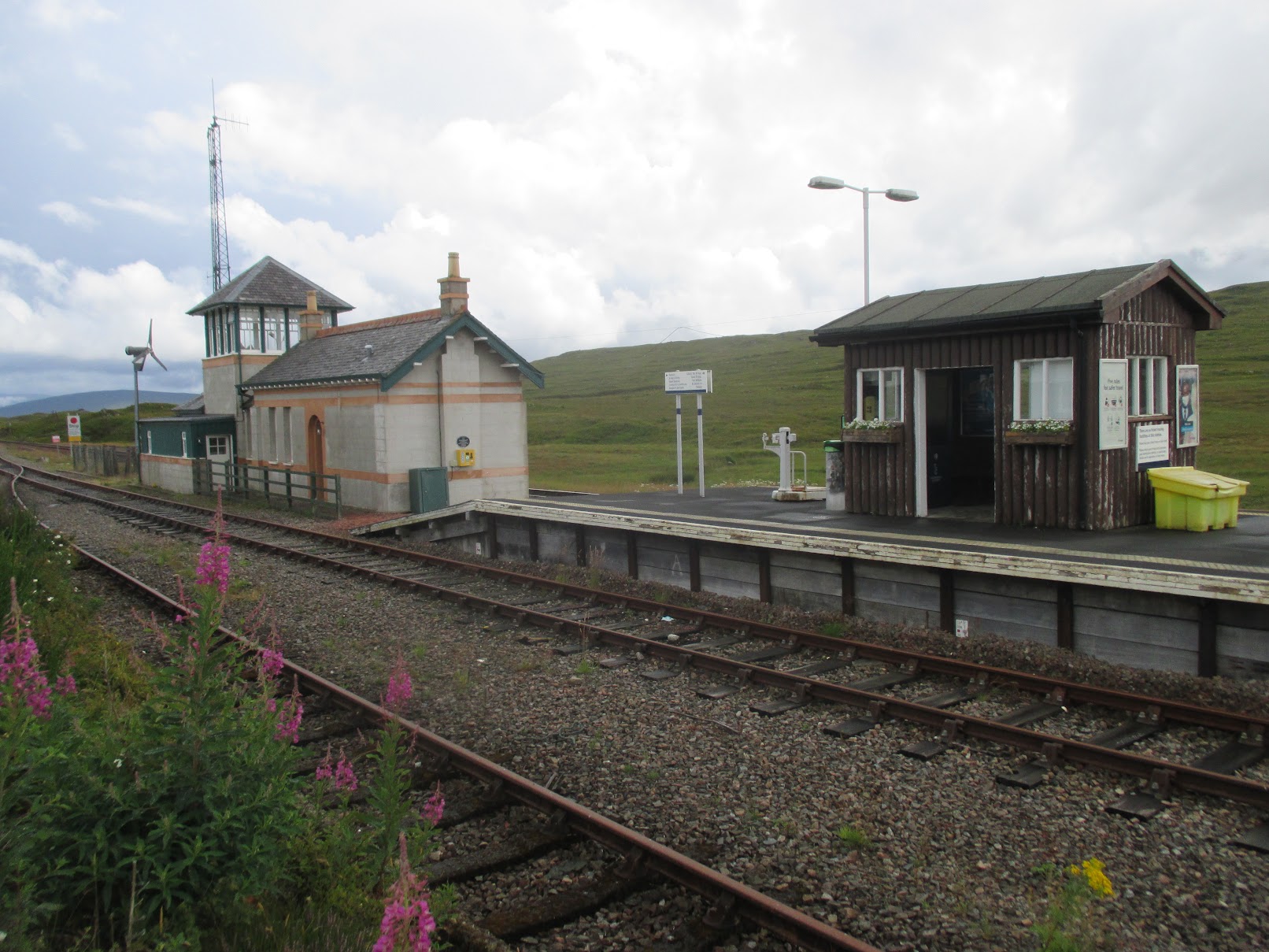
Corrour Station – the most remote in Britain
Corrour Station is the most remote railway station in Britain and it’s hard to see why it was built as there are no public roads that lead there. It does however have a restaurant and is a great way for walkers, runners and mountain bikers to access some of the more remote parts of Scotland.
The restaurant was great and I ate a BLT and a chip butty – both Scottish size servings and so had plenty of fuel for the next section to Dalwhinnie. The staff were also very interested in what we were doing, not having heard of such a long trek before, and wished us well as we departed.
Corrour Station to Dalwhinnie
We spent an hour at the restaurant and once back outside put on fresh socks. This was our first experience of midges. Annoying but easy enough to escape from if you just kept moving.
There was a wide path from Corrour Station down to Lock Ossian and things remained easy until the valley up to Meall an t-Slugain, which was again very boggy with no defined path, so a bit of a slog until we climbed up to a proper path on the south east side of the valley, which took us up to the col. After that we had excellent trail pretty much all the way to Dalwhinne, arriving there in good time at about 9pm. At this point we were all feeling great as we were half way, on schedule and still feeling strong (73km, 14h30 elapsed).
Dalwhinnie to Glenfeshie
At Dalwhinnie we’d stashed a cool box filled with food and spare clothes. I immediately put on a long-sleeved top and leggings as the midges were about. That plus a head net seemed to be enough to keep them from biting.
We boiled up water and each made a hot meal. That plus sorting out kit took about an hour and then we were off again in the dark on the next flattish section to our tent at Glenfeshie.
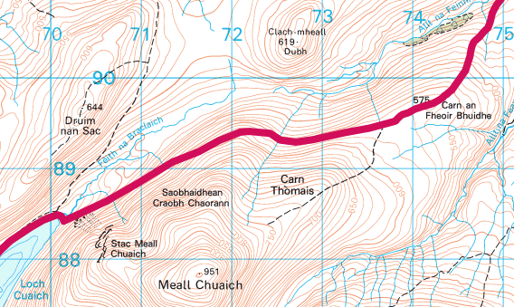
The path was wide and easy and yet none of us felt like running and just hiked into the night. Easy trail continued to Loch Cuaich, after which we were on a section with no path contouring the side of a hill covered in thick heather. This was only 4 or 5km but seemed to go on forever and was difficult to negotiate in the dark, with each of us regularly falling over. At least the heather was soft and on one occasion we all just lay on our backs, switched off head torches and stared up into the dark. The lack of progress was very frustrating but consulting the map didn’t reveal any viable alternatives. Relief came when we joined with a path coming down from Carn Thomais. By the end of this section our energy was sapped completely and Glenfeshie seemed a long way away.
The most demotivating section
Once we were back on paths things were much easier. The bridge for the River Tromie crossing had been washed away but there was another bridge not too far upstream that didn’t add too much extra distance.
I don’t remember too much about the next section other than us taking the path around two woods near Carn Dearg rather than following the route as plotted as by this stage we were very reluctant to try anything that wasn’t on a well defined path.
Reaching the River Feshie we were on the lookout for a place to cross as we knew there was no bridge other than the Pony Bridge that would add at least 10km. We ended up crossing at a wide section of the river approximately level with the Ruigh Aiteachain bothy. It was thigh deep and fast flowing but we all managed to stay on our feet. On the other side of the river just needed to bash through some woods to reach a track that would take us up to the tent.
We reached the tent, and the 107km marker after 25 and a half hours on the go. We were all very tired and looking forward to a good breakfast followed by a nap in the tent, where we’d stashed some sleeping bags, gas stoves, food and clothes. On opening it we quickly found that it was filled with midges. Any thoughts of spending time here went out of the window – our relaxing stop was now a dash and grab with little more than a change of socks and a restock of food in our packs.
Glenfeshie to Cairngorm YH
Leaving Glenfeshie we immediately started climbing into the Cairgorms on a wide track. This continued for 4km until we reached a plateau lasting around 8km before the next climb up to Cairn Toul, the first 4000-footer since we’d left the Lochaber range yesterday morning. This should have been easy but fairly soon the path petered out and we were trying to find our way across more boggy ground.
Boggy ground
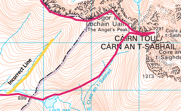
Lack of sleep was really starting to take its toll by now and I was scanning the ground for somewhere to sleep as we were above the elevation at which midges are found. Nothing was forthcoming but eventually Mark and I collapsed on a bed of damp moss and almost immediately fell asleep. I’d set a timer for 20 minutes but very soon it started raining quite heavily and sleep became impossible. The countdown timer still had 12 minutes left so could only have been a little more than a 7 minute “power nap” but it made all the difference and I was certainly ready to get up to the next summit. Nav here was again a bit tricky and we realised part way up that we were heading up the wrong side of Angel’s Peak, fortunately we caught ourselves before we’d got to a point where we needed to backtrack and could just contour round.
The ascent to Cairn Toul with incorrect line shown
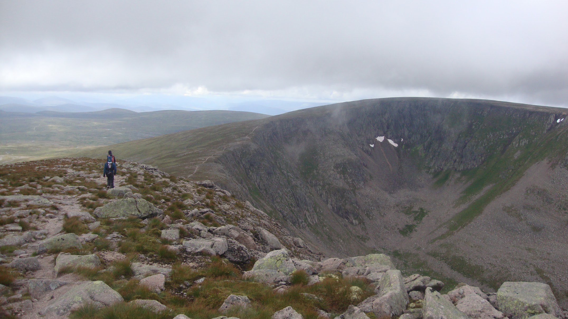
Up at Cairn Toul (122km, 30h), we started to see the majesty of the Cairngorms and impressive views when there were gaps in the cloud. From here we had an easy path to follow taking in The Angel’s Peak, Carn na Criche, Einich Cairn and Braeriach before a very steep descent into the valley before Ben Macdui. This was one part of the route that I was quite worried about as it was going to be steep down and up with no path marked on the map. The descent wasn’t too bad, with the initial bit done with feet, bums and hands and fairly quickly we were down at the stream and looking for the stream to follow up to Ben Macdui.
Between Angel’s Peak and Braeriach
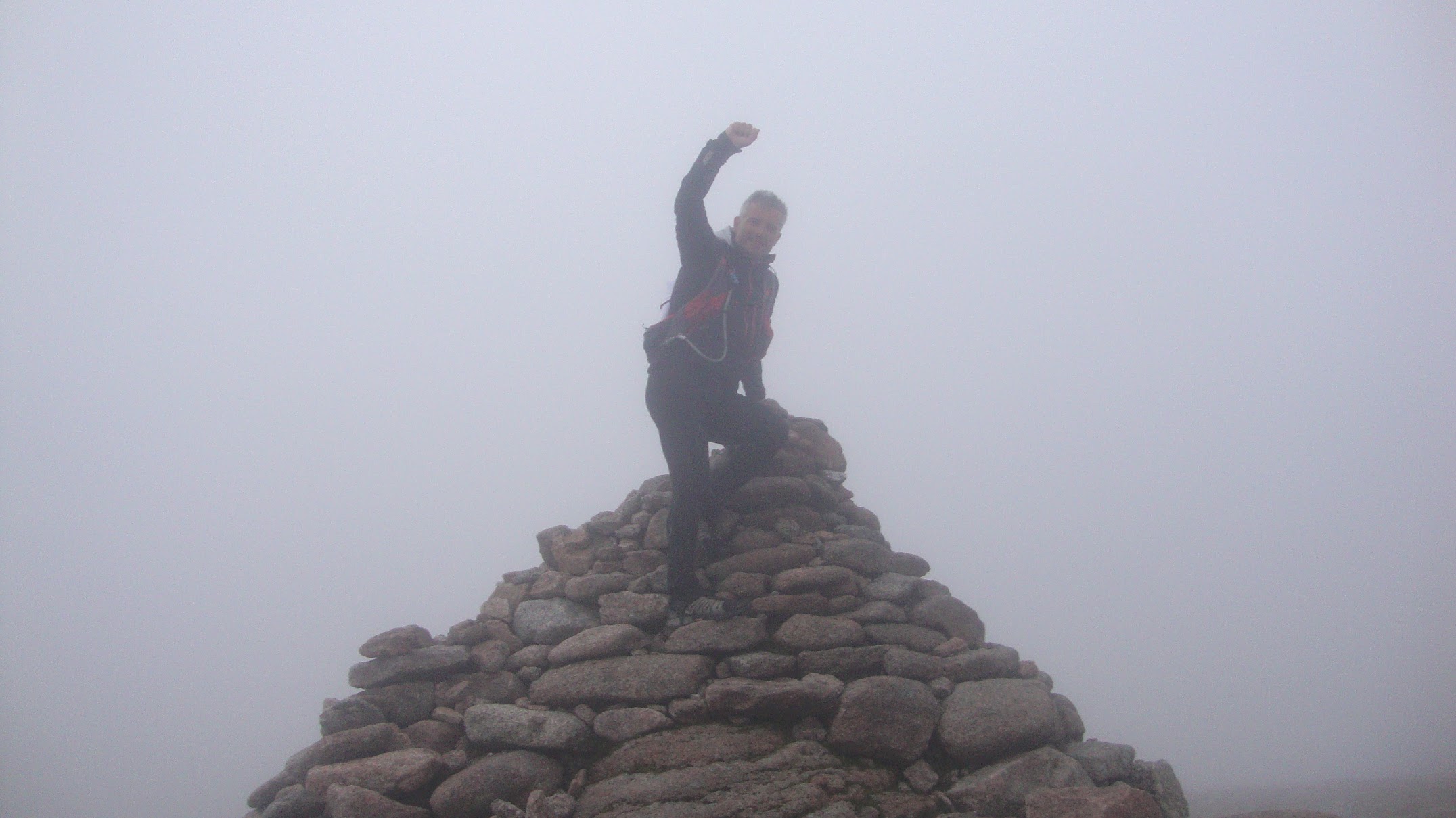
We’d read in a blog post that a sub-24-hour runner had managed the Ben Macdui ascent in 40 minutes so we knew it was going to be a lot longer than that for us. Hasan led the way and kept us moving. I monitored the elevation and rewarded us with a break each time we’d climbed another 100 metres. After 1h40 we made it to the top (134km, 35h). It hadn’t been that bad after all.
The steep bit
Now we just had a fairly easy run across to Cairgorm and then the final descent down to the youth hostel. It was looking like we’d be back in time for dinner – perfect!
Cairgorm was easy, although by this time I was starting to hallucinate quite a lot seeing signs in the distance that disappeared when you got closer. A little push and we were on the final summit (141km, 36h30).
The final summit – Cairngorm
It really was all downhill from here, 900m of descent, fairly steep to start with and then into the woods for the last few kilometres.
Lost in the woods
It was starting to go dark again and abruptly the trail petered out approximately 1km from the end. A few attempts at locating it ended in failure and we were starting to get worried as the undergrowth was dense making it difficult to make progress. My halluciations were now frequent and I kept seeing forestry signs that surely must be on a forestry track, but heading to each of these ended in failure as none of them were real. Now we were really getting worried as it was dark, we were lost, were heading to imaginary features and the midges were starting to attack. Ultimately, we decided to head back to pick up the road. This added another 6km and was hugely demotivating as there was now no chance of getting any food at the end, never mind a celebratory beer. In hindsight I’m pretty sure that we could have smashed our way through the woods for that final kilometre but turning back was the safest decision, as none of us were thinking rationally by then.
Finally we made it back to the youth hostel, cooked up a bit of chicken soup in the room and collapsed into bed. We’d made it. A total distance of 154km in 39h26.
After the Welsh 3000s and the Scottish 4000s the ideal would be the English 5000s, however those don’t exist. That said, 2022 should probably be based in England and most likely the Lake District. Maybe a Bob Graham Round, although not in under 24 hours for this bunch. Watch this space!
Back in 2018 my wife asked me what I’d like to do for my 50th. A repeat of my 40th with a gathering of friends and family would be enjoyable but nothing new. An interesting race on the other hand, well that would be something to get excited about. She agreed it was a good idea, so suddenly I had carte blanche to look look much further afield than the usual UK races. A browse of ultras at http://www.ultramarathonrunning.com/races/ didn’t reveal anything appealing in November but there was the Grand Raid in October, which was close enough to my birthday. I’d also been to Reunion for a fortnight of hiking some 30 years previously and so knew it was a lovely island with huge mountains. Now I just needed to figure out how to secure a place and then plan a holiday around it.
Looking at the details of the race it turned out that the Grand Raid was a banner for 4 races of differing lengths. The longest solo race was “Diagonale des Fous” at just over 100 miles with almost 10,000m of ascent – way more climbing than anything I’d done before but there was no way I was going for one of the shorter options. How on earth was I going to train for this? Box Hill and Leith Hill obviously weren’t anything close but there was no way I’d be able to get regular training in the Alps or anywhere like that so they would just have to do. Ultimately I embarked on a repeat of my previous Lakeland 100 training plan adding in as many ups-and-downs as I could to the usual Surrey Hills training routes. That plus building in two leg weight sessions each week was about all I could fit in. The plan started in in December 2018, so about 10 months of training.
Entries only opened in late 2018 and I wasn’t certain I’d get in. I therefore booked Lakeland 100 as another “A race” for 2019 thinking that I could either cancel that or use it as a training run if I did manage to get in. I did get a place and ended up doing both but couldn’t possibly treat the Lakes as a training run trying hard to beat my previous time. In the three months between them I worried that I’d blown it as recovery was slow leaving me knackered and sore after a 15 mile run. Three months was just about enough though, as by the end I was feeling back at peak fitness.
Getting to Reunion ended up being a bit more stressful than I’d bargained for. There are no direct flights so you either need to fly via Mauritius or Paris. I opted for the latter, so Heathrow to Paris CDG and then Paris ORY to Reunion. That’s two different Paris airports with a 90 minute bus trip between them – something I’d not spotted when making the booking but fortunately had plenty of time (to worry about being stuck in traffic on the peripherique!).
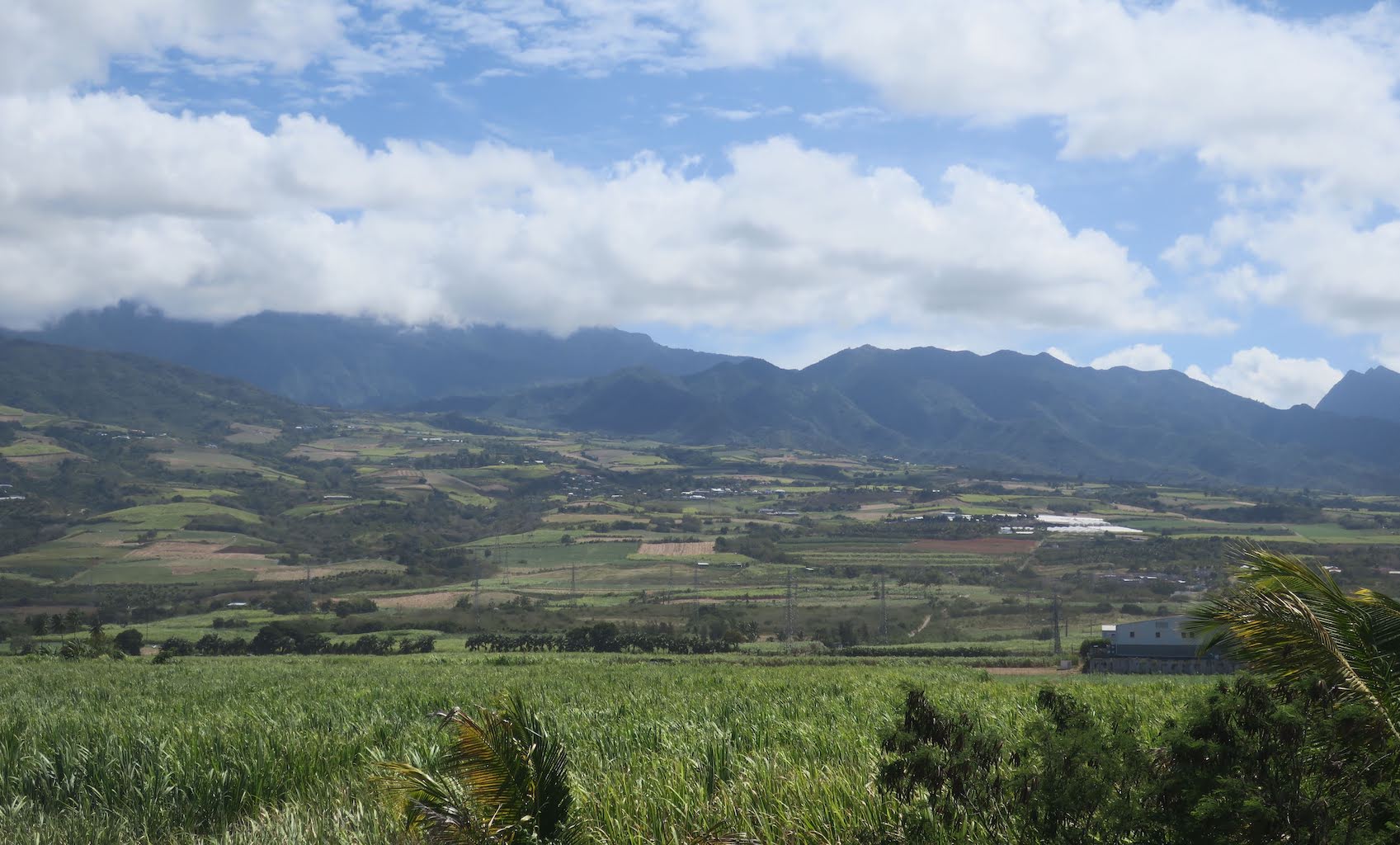
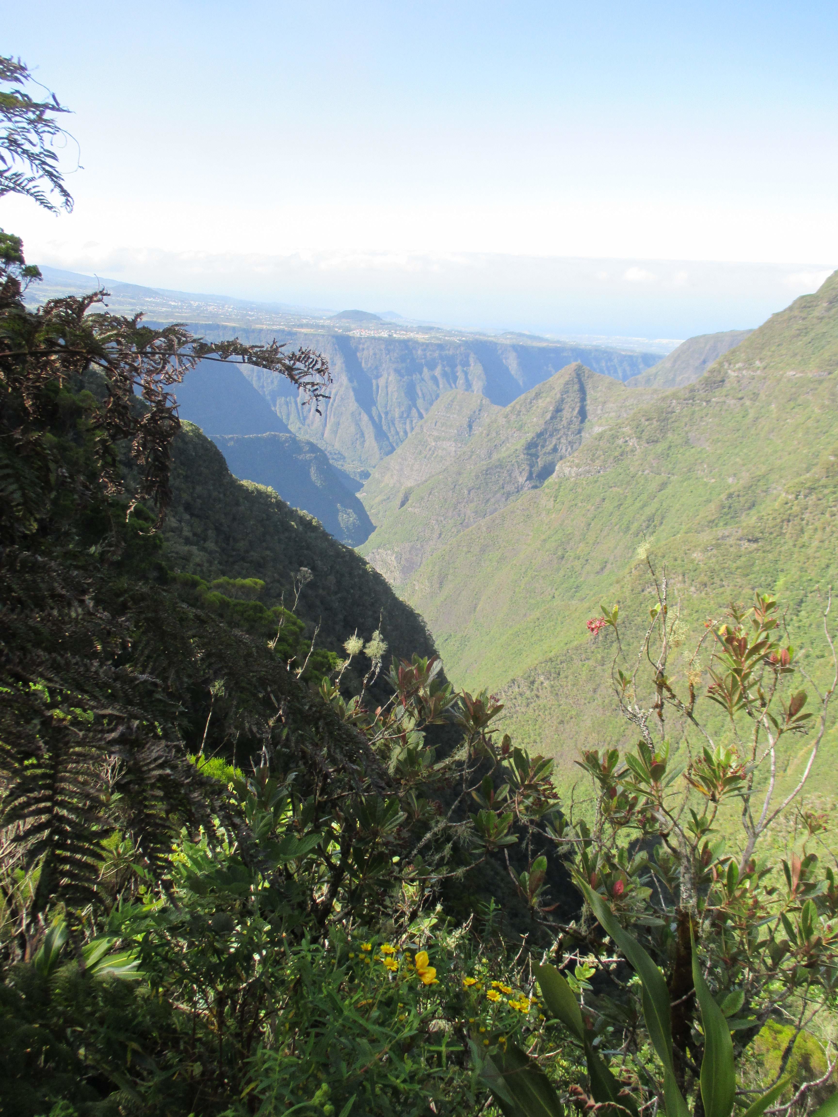
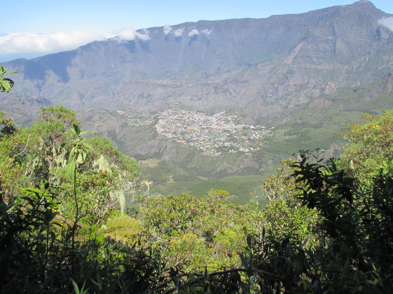
The day of arrival at Reunion I had to get to race registration before noon. Registration was at the southern side of the island, in St Pierre, with the airport and my hotel at the northern side. Cue another couple of hours on a bus. There were however some good views inland to the mountains.
First view of the mountains
Arriving in St Pierre I didn’t really know where to go but simply followed the sound of music blaring and made it to registration at the town hall before noon. Registration took about two hours with a rather long queue. Chatted to a few runners who had run it before and learned that some difficult sections of the course were not where I’d expected them to be – a 15km downhill dropping over 2000m had looked like an easy part but it sounded like it was going to be a quad killer – more stuff to worry about! It also sounded like my 45 hour target was a bit optimistic and that 50 hours was perhaps more realistic.
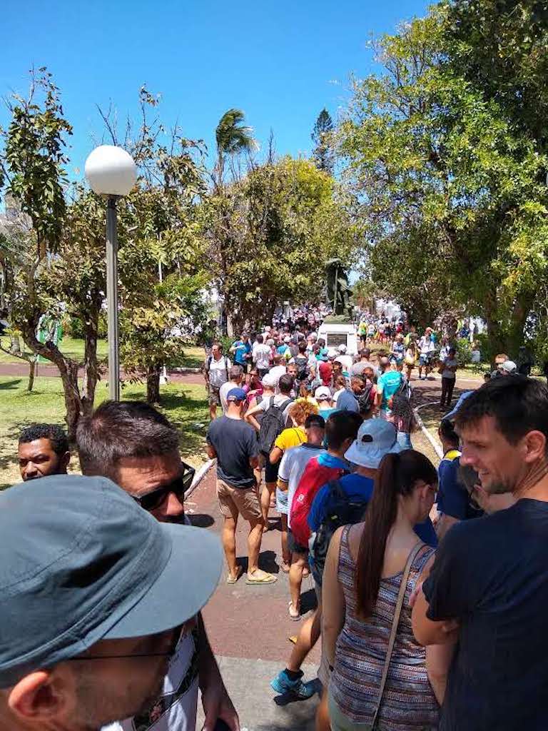
The queue for registration
Next back on the bus to St Denis to find the hotel and hopefully get a good night’s sleep as the following two nights (hopefully not three) were going to be spent running.
Amazingly I did sleep well that night, almost unheard of for me the night before a race. Now I just needed to while away a few hours before catching the race bus at 4pm back down to St Pierre. Somehow I managed to relax by the pool and then set off on a local bus to Roland Garros to catch the race bus. This was my first big mistake: Roland Garros is both the name of the airport as well as a street in town. I assumed the former but the bus left from the latter. Shit! Now what? Hasty enquiries and I found the next scheduled bus to St Pierre was in 90 minutes. That still gave me enough time to get to the race start but didn’t leave me with much time to relax before the race started. Not much else to do beyond wait and hope that the bus wasn’t delayed.
Three hours later and I’m back in St Pierre walking to the town hall to find the start. Get there and it’s dead. What’s going on?!? Second big mistake: not finding out where the race start was. In my defence that wouldn’t have been an issue if I hadn’t missed the race bus. Fortunately the town was buzzing near the sea front – all you needed to do was head towards the music. It was a long walk though – about two miles along a road lined with bands, dancers and crowds. The race is big news here!
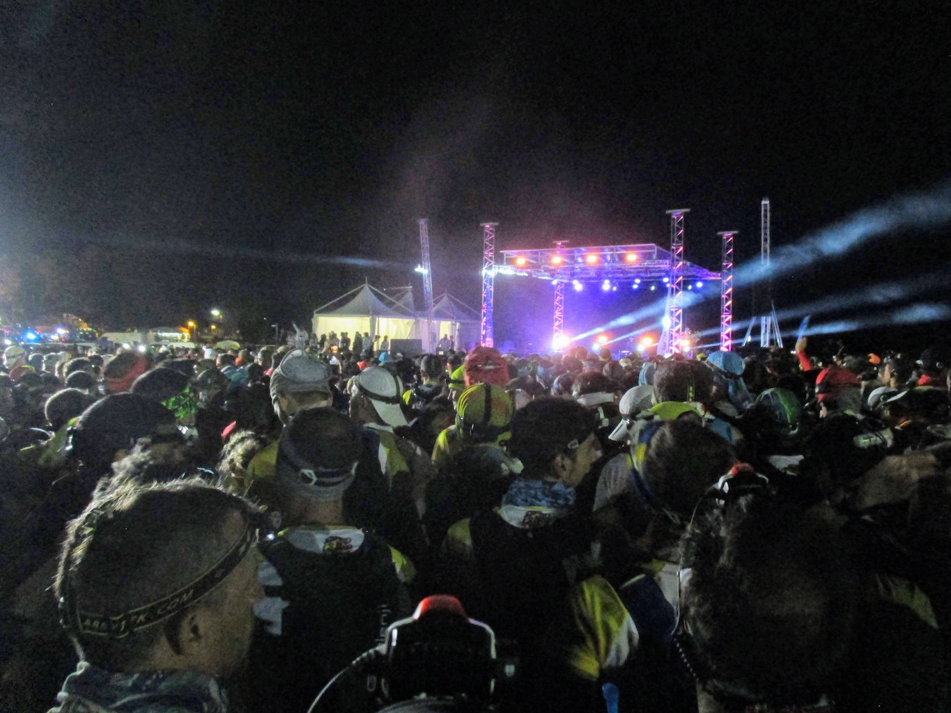
Eventually I make it to the start and there is a huge “queue” for kit check. This isn’t a polite British queue but just a mass of people pushing to get through a gate. Two hours in the crush and I finally make it into the starting area. I’m relieved but also stressed out – it’s only half an hour until the race starts. I’m hungry (haven’t eaten since lunch time) and need to find water to fill up the bladder in my race vest. The food tables are empty and I can’t find water. I can’t seem to find anyone that speaks English. This is not the way to start a race! Eventually I find a half empty water bottle next to a bin. It smells OK so it’ll have to do – should be enough to get to the first aid station. Now try and relax.
Ready to start
Soon enough the crowd starts inching forward so the race must be about to start. I’m right at the back but really don’t feel like pushing my way into another crowd. The crowd starts walking so I guess the race started (no idea what’s being said over the PA). Start the watch going and soon start jogging along the seafront. The crowd is even bigger than before, filled with bands and dancers and it goes on for miles. There are fireworks going off too. This is an amazing atmosphere but my head isn’t in the right place to enjoy it – I’m still stressed-out, sick of crowds and just want to run. I try and talk myself round – “this is it, this is the race you’ve trained all year for, enjoy it! Soak up the atmosphere!” but I just can’t switch moods.
After a few miles we leave town and start ascending through the cane fields. The crowd is thinning out a bit now so I can run at a nice easy pace. We pass through villages, each lined with people shouting “allez! allez!”, fortunately I’m starting to enjoy things – all the stress of the start has faded and I’m looking forward to getting up into the mountains and seeing the dawn.
Nine miles in and suddenly we stop, and not just briefly but for minutes. We are now on single-track and I’m towards the back of a queue of 2700 runners (at this point I was around 2000). 6 miles of stop-start follow but I try not to let it bother me – try to think of it as enforced rest that will help later. That kind of works and soon enough I reach Aire du Nez de Boeuf, which is the top of the first long climb.
Around then dawn breaks illuminating the 3000m peak of Piton de Neiges. There is frost on the ground so it really was close to freezing overnight. I can spot the mountain hut where we spent the night on the way to the summit 30 years ago. It’s a shame the race doesn’t take you over the top but then again this is going to be tough enough without an extra climb.
The next section is relatively flat and runnable and I’m enjoying it. Definitely passing plenty of runners and even some who sleeping at the side of the trail. I don’t feel the slightest bit tired and plan to keep going well into the second night before thinking about sleeping. I do wonder if they know something I don’t though.
Next up is the really steep descent down to Cilaos complete with chains, ropes and ladders. One of the blogs I’d read spoke about needing gloves to protect your hands and of people falling and ending their race here so I was a little worried about just how difficult it was going to be. Ultimately it was a long steep descent but not overly technical. You could spot the local runners though as they just flew down.
Reaching Cilaos was a major milestone. Huge crows cheering you in. Here was where you got your first drop bag so that meant fresh clothes, new shoes, proper food. I spent at least half an hour here freshening up and getting ready for the next section through Cirque de Mafate, which was going to be the hardest with two major 1000m+ climbs and another night before heading down to the coast.
Out of Cilaos in the midday sun with the big climb up Col du Taibit (2142m) ahead . Some of my running buddies reckon I’ve got a “diesel engine” when it comes to long climbs so I try to invoke that now and manage to stay feeling strong with a steady pace all the way up and then over into Marla. I gain 300 places over that section so it must be true.
Ready for Cirque de Mafate
Leaving Marla the trail descends into Cirque de Mafate, the most remote part of the route. There are no roads here and the aid stations are all supplied by helicopter. I’d heard you couldn’t drop out at any of the aid stations here and had to make it out to Maido. That could have been intimidating but I didn’t feel that there was any real danger of me not making it another 30 miles. Descending into forest it suddenly went dark and started to rain. Looking at my watch it wasn’t even 6pm so the next 11 hours or so would need a head torch – it was going to be a long night.
At this point I’d not had a conversation with any other runners. That’s very unusual for me as I almost always get chatting to someone on the trail, which is a great distraction that can get you through a few hours without noticing. Almost everyone in this race is French and I barely know enough to order a beer so conversations just weren’t happening. At one of the aid stations though another runner asked “are you English?” – he must have heard me trying to communicate with the staff. We quickly struck up a conversation – I was certainly glad to have someone to chat to, which helped a lot getting through the second night. Ultimately we stuck together right to the end of the race so I expect he was glad to have the company too.
Conversation kept us moving well until the big climb out of Mafate up to Maido. This was a monster climb of 1300m that we started at about 2am. Sleep deprivation was now becoming an issue and I wasn’t as sure-footed as usual. The trail was a zig-zag carved into the near vertical side of the mountain so there wasn’t anywhere to sleep. It was time to get that diesel engine chugging away again, although by this time it was spluttering quite a bit.
Three hours later we crested the summit and I was now struggling to stay awake but couldn’t stop to rest as I’d run out of water half an hour before. Fortunately it was an easy ridge run to the aid station – a place to get water, food and hopefully a nap. There was no place to sleep inside and it was pretty cold and windy outside. Continuing to the next aid station wasn’t an option so I just put on all my layers and curled up on a stretcher outside with a countdown alarm set for 20 minutes. Having never before slept during a race I had no idea if I’d be able to nod off but the alarm woke me so I must have. I was bloody freezing though! There was frost on the ground again so it was time to get running to warm up. Next was the long descent to Ilet Savannah that I’d heard about. I hoped my quads were up to the task.
The descent was indeed long: 1875m over 15km but really not that difficult. I did trip up once on the way down though (my only fall of the race) and by some miracle landed in a soft bush – right next to a nasty spiky one. The descent ended at Ilet Savannah, a town near the coast, which was the next big aid station with the second drop bag. There were showers here too, so even though I had no soap or towel I took the opportunity to freshen up, change clothes and give my feet some attention. A quick hot meal and it was time to tackle the last 25 miles with two 800m climbs. That really didn’t sound like a lot, although it was getting hot already.
Two little climbs to go
The first of the climbs felt easy enough and the terrain for the descent was some interesting scrambling over boulders filling a ravine, which ultimately took us down to La Possession at the coast. Only one more similarly sized climb left now – this should be easy.
Ha! I wish! I’d read about Chemin Anglais being this horrible track that destroyed you but didn’t think things could be that bad with just the one climb left. It was bad, really bad. Thinking back it’s hard to say just why. The track itself was in distinct sections of entirely different character, almost as if it had been constructed by different people. It started off as a paved jeep-sized track made of flattish rocks fairly evenly put together. It didn’t look that bad but somehow the surface made each step a little different so that took away any rhythm. A sudden change in character and it was now as if builder #2 had decided not to bother laying any of the stones and had just scattered them willy-nilly. Somehow that seemed worse than no trail at all. A few more changes of character, all sudden and distinct but never making the going any better. The climb seemed to go on for ever and sapped every last bit of physical and mental energy. I swore at lot and can’t have been much fun to be around, but somehow made it to the top of the climb where there was a beautiful grassy meadow and the final aid station before the descent to the finish.
Chemin Anglais
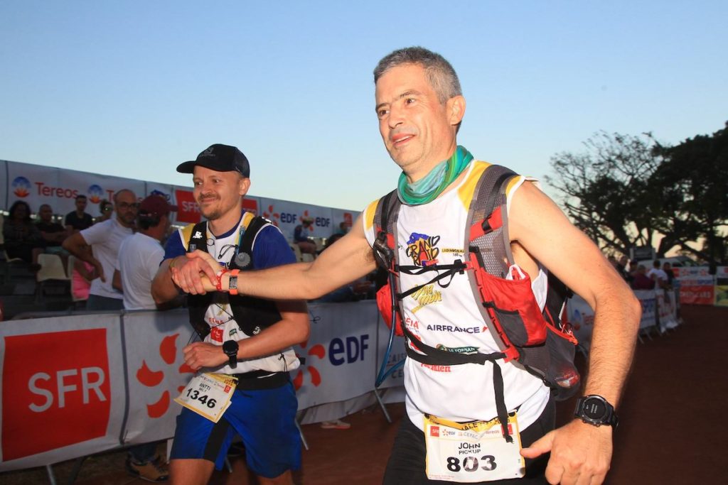
Only three miles left now, all downhill and I can hear the music from the stadium at the finish. My watch says 43:30 – surely we can manage to sneak it in in under 44 hours? I ask Antti if he’s up for a final challenge. He doesn’t seem that keen but agrees to give it a try. At this point we have to put the official t-shirt on as you have to cross the finish line in it; there’s a time penalty if you don’t (the French have some weird rules).
With the end so near my legs feel brilliant and I’m flying down, overtaking loads of runners who all seem to be struggling. Sub-44 is slipping away but I don’t want to stop trying and keep on pushing. Eventually the trail comes out at a road and the stadium is there. Crowds of people lining the entrance clapping and cheering but no sign of Antti. He can’t be that far behind can he? After having stuck together for half the race we can’t not finish together so I stop and wait for what feels like an age. It seems that everyone I overtook on that last section is now passing me again. I’m starting to worry that he’s fallen and injured himself but he does turn up and we finish it together.
The end
Before this race I’d decided it would be my last 100 miler. 2020 was going to be all about Mountain Marathons; 100s were just silly really. Chatting to Antti it turned out that I now had enough points to apply for a place at UTMB. That’s never happened before and is unlikely to happen ever again. I don’t have much choice really, just one more then…
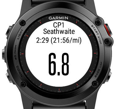
I’ve recently built a ConnectIQ watch data field that shows information about checkpoints during an activity. It is built for the Fenix 3 for use on a single field screen of an activity and shows the name of the next checkpoint, distance to go, time until cut-off and average pace required to get there within that time.
Here’s a screen grab from the simulator:
This came about after experiencing that in the middle of the night, many hours into a race, it’s quite easy to get mixed up, especially if you’ve been lost previously so you need to keep a delta in your head of distance on watch versus distance on course to compare with the checkpoint distances you have written down.
The operation is very basic. It holds the lat/lon of every checkpoint, distance between them and their cut-off times. It has no idea of the course you are following, just the expected distance to the next checkpoint. It checks if you are within 200m of the checkpoint, and if you are then switches to the following one, resetting the accumulated distance to zero and comparing this against the distance to the next CP. Additionally it looks one checkpoint further in case you happen to miss one. Also, as it’s not aware of the actual course it can go wrong, e.g. if you get lost and add on a few extra miles then it’ll misreport the distance to the next CP until you get there, after which it’ll get back in sync.
The other major problem is that I currently have no way of setting up the checkpoints other than by modifying the code and loading the updated data field to the watch. I’m yet to find a way of getting this kind of data onto the watch in a user-friendly way. Of course this is fine for me as I’m the only user but clearly means that the data field is of no use to anyone else unless they are comfortable with Eclipse and the ConnectIQ SDK.
The source is available on GitHub if you wish to customise this field for your own race:
I was asked recently to help out someone with a few features on their Garmin training watch and it made me realise that a lot of the features that I regularly use on my watch aren’t that obvious meaning that people often don’t get the most of a very capable device. Here are a few things that your watch is really good at.
Workouts
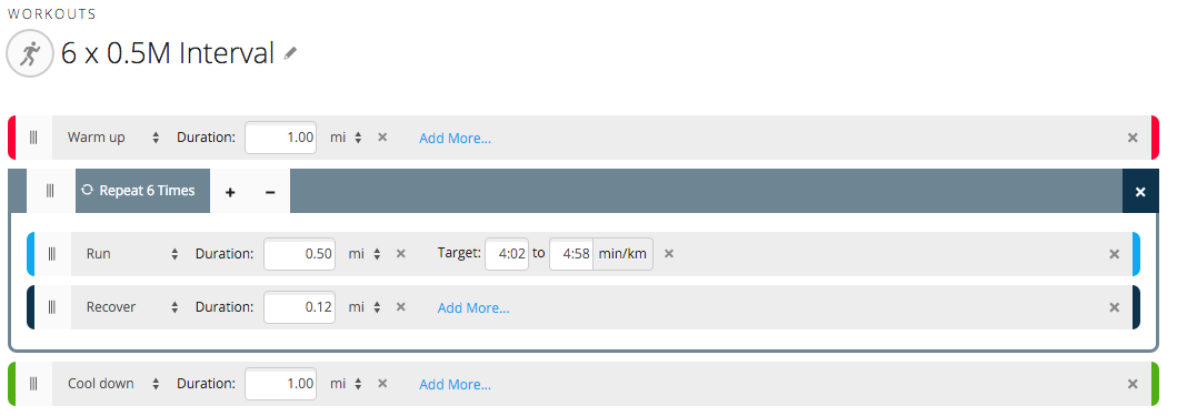
Workouts allow your watch to direct you such that you are achieving your goals during a training session. By goals we mean things such a speed, pace or heart rate over a time or distance. For example you can have your watch warn you if you are not staying within a pace goal of 7:00 – 8:00 min/mile over a distance of 800 metres, warning you if you are going too fast or too slow, similarly you can set goals for your heart rate to be within a range of 70% to 80% for 10 minutes. Workouts can be structured meaning that they are a series of goals that you follow one after the other, a classic example is an interval session with a warm-up and cool down:
Tips
When you complete a workout the watch plays a little tune and then stops the activity. That’s fine if you are on a treadmill but chances are you’ve still got a way to go before you are really done. It’s possible to continue the workout but you will lose a few seconds; instead add an extra “no target” step to the end of every workout and just stop the watch normally when you have reached the end.
The watch can get pretty annoying with pace alerts if you’ve set a fairly narrow desired range, especially if GPS accuracy isn’t great. It’s therefore better to have a wider range and treat it is a “always go faster than” (have a really fast upper bound) or “always go slower than” (have a really slow lower bound)
Training plans
A training plan is a calendar where you define particular workouts that you should complete on a given date. This is a great benefit when you head out first thing in the morning and can just fire up your watch and say “do today’s run”. The watch will then tell you when to speed up, slow down, work harder, ease off, etc.
It’s quite a lot of effort to set all this up in Garmin Connect but once it’s done it can be a great motivator – you just do what the watch is telling you with no deciding what you feel like at the crack of dawn!
Navigation
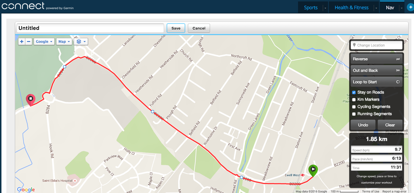
The easy way
Plot a route on Garmin Connect, clicking your way round the map.
In Garmin Connect go to Courses and click the plus button to create a new course. Next:
Type in a place name close to the start to centre the map on that and zoom in until you find the right spot
Click once on the start point and this will drop a green marker
For a road route leave the “stay on roads” option checked as this will allow you to click infrequently with Connect figuring out the route between two points; for trail you are better off switching this off and clicking points more frequently (Connect will just draw a straight line between each point)
Type in a speed or pace on the right hand side – this govern the speed of a “virtual partner” you can compare yourself when following the course.
Give the course and name and hit Save.
Click “send to device” and connect your watch
On the watch go to Navigation | Courses and find the newly uploaded course and hit Start and Do Course.
Select the type of workout (run, bike, etc), wait for a GPS lock and then his start
You’ll now have a map screen as one of the screens you can scroll to where you can see the path ahead and a track of where you’ve been. the watch will give you alerts if you deviate from the course and again when you rejoin it.
A better way
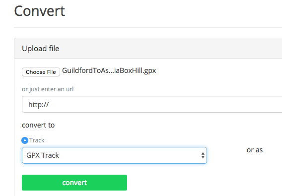
Garmin Connect’s interface is quite limiting and there are better alternatives for creating routes (RideWithGps, Mapometer, Ordnance Survey, etc). Connect also doesn’t have a way to import routes from other sites or sources, which often will allow you to download a route as a GPX file, for example from a race website or in an email from a friend. In these cases you need a way to transfer a route that is saved in a GPX file onto your watch and this can be tricky; it also differs depending on the model of Garmin you have.
With the newer Garmin watches after connecting the watch it should appear as a folder on your desktop. Open this folder, inside there should be a Garmin folder and in there a NEWFILES folder; this is where we need to copy the GPX file. By default the NEWFILES folder is hidden so you’ll need to enable display of hidden files and folders to see it.
Copy the GPX file from your PC to the NEWFILES folder above and then “eject” the watch. After doing this the watch should display “Updating” for a few seconds and then return to the regular screen. The new route should now be visible in the list of courses in the Navigation menu.
NOTE: For this to work you need a “GPX track” as opposed to a “GPX route” the wrong type of GPX file results in the watch ignoring the new file,so look for an option for a track rather than route when downloading.
If your GPX file doesn’t work then use the as GPSies converter to change it.
Turn-by-turn navigation
The more recent Garmin devices also offer turn-by-turn navigation. This is very much like a car satnav that alerts you shortly before a junction that a turn is coming up and displays information about the new direction and a description, such as a street name.
Auto-zoom automatically zooms the map display on the watch in or out such that you can see the track even if you’ve moved some distance away from it. This sounds good in principle but in practice when briefly looking at the display you can’t see how far the next feature is without scrutinising the scale. I therefore recommend leaving this off and zooming manually when required.
Circular routes can sometimes confuse the watch as it thinks you’ve already reached the end before you’ve even started. Onesolution here is to start the watch a little way after the start.
The watch can alert you that you’ve left the course even when you haven’t, this can be as a result of poor GPS accuracy (see under thick tree cover or in a city) or from inaccuracies in the route loaded onto the watch from either an inaccurate set of route points or points taken from poor map data.There isn’t an infallible solution here beyond building up experience of how much to trust the watch.
Very long routes can also be problematic and take a long time for the watch to load. One solution here is to split a very long route into a number of smaller segments, switching from one to the next during the activity. This is a bit of a faff both in creation and during the activity so I’d recommend putting both the long route and the shorter ones onto the watch and using the shorter ones as a backup if you encounter problems.
Charging on the go
For very long workouts the battery life of your watch might not be sufficient for the duration of the workout. In such cases you have a few choices:
Switch off all unnecessary features on the watch, such as smartphone integration, to save power
Change to “ultratrac” mode
Charge the watch whilst using it
I prefer the latter as I like the watch to be accurate and full-featured during a race. To charge the watch you need a portable power pack such as the Anker PowerCore mini, which has sufficient power to change the watch multiple times. Note however that not all power packs work, some I’ve tried don’t recognise the very small current draw of the watch and switch off rather than continue charging. In addition to this you also need to switch the watch’s USB mode to “Garmin” so that it can continue with the workout when a charger is connected.
The Centurion NDW100 was my second 100 mile race, having successfully finished SDW100 just a few months earlier. That first hundred had gone remarkably well so I was confident that I could repeat this on the North Downs. Aware that the NDW typically took an hour or two longer to complete I naively thought that I could push a bit harder than I had on my first hundred and so a sub-25 should be achievable and maybe even another sub-24, also this time I wasn’t going solo the whole way but had a pacer (my brother) to keep me motivated for the last 25 miles (the night section). A lot of the route is also familiar territory for me as the majority of my long training runs take place in the Box Hill area leading to more overconfidence.
As the SDW had been so successful I tried to keep everything the same: fuelling, hydration and kit. I did however have a new watch, a Garmin Fenix 3. I’d been training with the watch for about a month and was sure that I had it setup just right for navigation and pacing, but disaster struck just a mile into the race: the watch kept locking up so I wasn’t getting any info or notifications. After a lot of messing about it seemed that course navigation was the issue. With nav disabled the watch was back to giving me useful data again bar guidance for the route, which was only really a concern after Knockholt Pound as I didn’t know the second half. I just hoped that Centurion had done a good job of marking the course.
With that problem out of the way I could start running at relaxed pace and enjoy the course. It was a beautiful sunny day and fortunately I don’t suffer in the heat so I was making steady progress, sending regular updates to my family who were going to be at the top of Box Hill to cheer me on. I was really looking forward to seeing them 25 miles in and those 5 hours just flew by, reaching Box Hill about 10 minutes ahead of schedule and feeling great. A few minutes at the top chatting and then it was time to get going again so I departed shouting “see you in 50 miles!” to my brother. Not long after that my mood took a turn for the worse. This was down to me fixating on just how far that next 50 miles was. Reaching the aid station at Reigate was a big lift and suddenly the race didn’t seem quite so intimidating and I was once again able to break the race down and focus on getting to the next aid station.
The section from Reigate to Knockholt is a bit of a blur but I remember reaching Knockholt feeling good and appreciating fresh clothes from the drop bag and some hot food. The volunteers there were brilliant, taking care of your every need so I set off on the second half of the race feeling refreshed and strong. Things were still going well until darkness fell at around the 65 mile mark. At this point I was on a wide straight track so I took the opportunity to send a quick text message to my brother to tell him I was about 10 miles away from Bluebell Hill so he could start making his way to meet me there. Five minutes later I’m still on the same track but can’t remember the last time I saw any marker tape. Yep, I’d missed a turn, most likely whilst sending the text. Backtrack and eventually find my way up to the aid station on Holly Hill. Cue another downer – 10 miles in the dark until I saw my brother suddenly felt like a very long way. It was at this point that I started to struggle mentally – my pace was slowing and every time I calculated how long until Bluebell Hill it seemed it was even more time to go. Eventually the ETA did start getting closer and before long I was hiking up Bluebell Hill reaching the top a little after midnight.
I expected the final section to be quite straightforward, a pacer to keep me motivated, a course that looked easier – this was meant to be a doddle! Once we’d got past the climb out of Detling I was expecting a nice flat trail to the end but instead it felt like we were doing repeats up and down the stairs at Box Hill, so once again I was struggling as things were so much harder than expected. We battled on and finally made it to Lenham. By now the sky was starting to brighten and my mood lifted – not long to go now! The last 10 miles or so passed without incident and being flat I found it easy to have my brother to set a pace and just focus on following his heels. The final miles ticked away, so no walk breaks now, we’d almost done it. Into Wye and superb efficiency from the volunteers at the end supplying drop bags and bacon rolls made for a happy finish.
The race was so much harder than I’d expected and left me questioning whether I wanted to do any further races of this length. Just a couple of weeks later and I’m already planning the calendar for 2016 and naturally it’s got an even tougher 100 in it. This ultra lark is addictive, isn’t it?
Discussions around Garmin versus Suunto as training aids often seem to highlight very little other than folks saying “I’ve bought X and it’s the best” with very little to back up the statements. Having used devices from both manufacturers I consider myself to have a fairly unbiased view of the strengths and weaknesses of each and was asked recently which one I’d recommend, which led to a conversation about the particular needs of this runner and me thinking more broadly about who is best served by each device.
I’ll start with a bit of history about the watches I’ve used and the strengths and weaknesses of each.
My first running watch was a very basicPolar HRM that was little more than a stopwatch with heart rate display. It did the job but only because I was unaware of just what a watch could really do as a training aid. Buying a Garmin Forerunner 305 changed all that!
Since then I’ve become somewhat reliant on a watch as a training aid, navigational aid and motivator. This is generally good but can also be a problem if the watch lets you down and you are too dependent upon it.
Garmin Forerunner 305
The FR305 was my first proper training watch. I bought it in 2007 it revolutionised my training. At the time I was training for half marathons and training runs were transformed from what was often a chore into something much more challenging. For the first time I was able to have instant feedback on pace and distance and have a watch that could give alerts when outside the desired parameters.
Garmin Forerunner 310XT
I didn’t actually own this watch, I bought one for my wife as she was getting into triathlons but did on occasion use it if I needed more battery life. It was really a very small step up from the 305 with longer battery life and some triathlon features. It also used ANT to communicate with the PC rather than a wired connection but this was quite flakey. That combined with the fact that you still needed to plug it in to charge it meant that there really wasn’t that much benefit to being wireless. It certainly didn’t offer me any new features versus the 305 and had some bugs when displaying routes on the map screen (sometimes you saw nothing). I preferred the 305 apart from the fact that the battery wasn’t up to the duration required for the kinds of events I was now entering.
Suunto Ambit 2
Eventually the 305 started to become unreliable. It had stopped being waterproof a while back and now flooded if I was out in the rain. I think that eventually got to it so it needed replacing and the Ambit 2 looked to fit the bill.
The Suunto was a big change for me coming from Garmin but not terribly difficult to understand. The device itself was much smaller than the brick-like Garmins such that it could be worn as a regular day-to-day watch, albeit a somewhat bulky one. I was also attracted to the ability to create your own apps and very quickly knocked-up a run-walk app that gave me alerts such that I could stick to a 5:1 cycle in ultras; later on I added further alerts for eating and electrolytes.
I was however disappointed by a number of things. First off navigation. The “map” display was really very basic with just the planned route and your current location. Missing were a breadcrumb trail of where you’ve been, display of any saved locations nearby (only waypoints created as part of the route are shown) and no ability to zoom manually. There were also no alerts if you went off track. The Garmins had had all of these features so I had expected this or something similar. What this meant for me was that I could head off track without realising, look down at the watch and potentially not know which part of the visible track I should head for. In one race I managed to get lost in woods, lose my sense of direction and use the watch to navigate back to the route only to find this was a place I’d been a couple of miles earlier. The lack of zoom and breadcrumb trail was the problem here. Admittedly a paper map would have been a better option but I’d got used to the Garmin giving me enough to not really ever need a map.
The other big disappointment was the lack of training features. The “revolution” in my training mentioned above in part came about because I could plan my training months in advance with all kinds of different workouts with different pace goals. On the day I would just head out and ask the watch for today’s workout and get going. The Suunto seemed to have nothing. Intervals were ridiculously basic – just a single one where you set the durations but no goal pace or limits that could be set. Gone were the days where one day I’d run 8x400m and another day 4x1600m with different pace goals. I ended up just running mile intervals week in, week out and without the watch “moaning” that I was going too slow I just couldn’t keep focused enough to put out enough effort for a full mile. I definitely got slower in the year or two that I trained with the Suunto.
Another minor issue was the lack of alerts for low battery. There is a tiny indicator at the bottom of the screen but it was hard to distinguish if it was on 20% or 2%. In one race I let it get too low before connecting the charger and got an alert which gave a few seconds before switching off. Very annoying as once the charger was connected and the watch got going again the activity was logged as a brand new one. At least the old one was saved though.
You might get the impression that I didn’t like the Ambit but that’s not true. It was a rock-solid watch with did what it was designed to do very well it just didn’t quite live up to my expectations. At the time I was looking to buy it I also looked at the Garmin Fenix 2 but the reviews made it clear that it also wasn’t the watch for me as it wasn’t really designed as a running watch, it was more like a wrist-mounted Garmin outdoor device and so lacking all training features (or at least that’s how I understood the reviews).
Software Stability
The Ambit is rock-solid but the Suunto website (Movescount) had some extended periods where it was unavailable. This is a big deal with the Ambit as you can’t do route creation or change any of the configuration without using the web-based app.
Garmin Fenix 3
When the Fenix 3 was announced it sounded like exactly the watch I was after. Everything good found in the Ambit 2 plus all the features I’d been missing from the old Forerunners. The only problem was I couldn’t possibly justify spending all that money so soon. There was nothing wrong with the Ambit really, was there?
In the end I decided that I’d use the Fenix as a “carrot” to get me through my first hundred and set it as a reward if I could go sub-24. I succeeded and so ordered one within a couple of weeks of finishing the race. I wasn’t disappointed – this was a big step up: colour screen, smart phone integration, wireless connectivity (that worked), all the bells and whistles.
Returning to a Garmin device was great. Back to proper structured workouts with pace goals and navigation screens that really helped navigation. The colour screen helps here too as the display is really clear. There is also a ridiculous level of configurability of screens shown during workouts, even better these can be changed whilst out running so you can adapt the screens when you realise what you need rather than try and remember just what you wanted when you get home. This really came into it’s own during the night section of a race when I wanted a big single field display that was easy to read – easy, just did it then and there.
The Fenix is also smaller and lighter than the Ambit, not by much but enough that it’s more comfortable to run with for long periods), it also feels more comfortable as a daily watch so I now wear it all the time rather than just when out running.
Accuracy
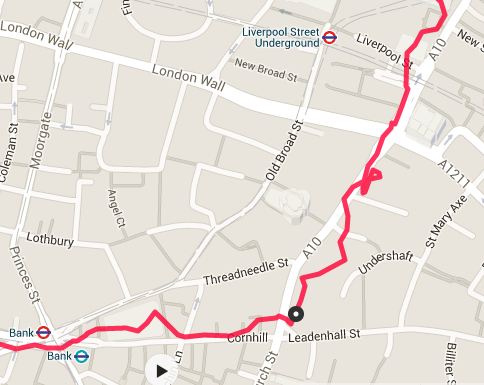
There’s been a lot of noise in the forums about the Fenix 3’s accuracy. For general trail use it’s spot on, even under tree cover, however in the city surrounded by tall buildings it is quite a lot worse than all previous watches I’ve owned. This can be seen in the tracks from the 3 watches and shown here (taken years apart so not a scientific comparison but representative as this is a route I run frequently and day-on-day each watch performs much the same with very similar errors):
Garmin FR305
Suunto Ambit 2
Garmin Fenix 3
The Fenix 3 looks to be the worst of the lot here and the Ambit is the best. Fortunately for me I’m not too bothered about GPS accuracy in built-up areas and I don’t for example, see problems of this nature when running trail, even under heavy tree cover, so really this is a minor annoyance for me, the only real downside is that I end up with ridiculously fast stats for the final mile of my run to the office.
Navigation
Uploading routes to the Fenix 3 isn’t terribly easy. You can plan routes on the Garmin Connect site and send them to the watch but I prefer to use other sites for route creation which result in a GPX file that you then want to send to the watch. The watch also supports turn-by-turn navigation (much like you get from a car Sat Nav) although that requires files of a very specific format that need custom tools to create (Running Badger’s converter). In terms of getting a GPX onto the watch there are a number of approaches but the only one I’ve found to work reliably is to import the GPX into Garmin Training Center and then upload to the watch from there. A bit of a faff though. Garmin really need to allow GPX uploads for route creation in Garmin Connect just like you can in Suunto’s Movescount.
Software Stability
The Fenix 3 has had some pretty shoddy software updates over the last year. v4.0 of the firmware was really, really bad and resulted in the watch letting me down during the NDW100. I’m pleased to say that v6.5 and v6.8 have been very good so hopefully those days are behind us.
One big benefit of the Fenix 3 is that you can do pretty much everything on the watch, even reconfigure screens during a workout. You therefore aren’t reliant on Garmin Connect being available to work with the watch.
Conclusion
The Garmin is a more feature-rich watch but is not without its problems. It also requires a bit more technical ability to use all the features. For me it is the stand-out winner. I was recently asked by a runner which one to get, and after a long discussion about their requirements and how comfortable they were with technology in general in ended up recommending the Suunto so it really does depend on what the key features are for you.
Of course the comparison here isn’t really fair as I’m comparing Garmin’s latest offering with the previous Suunto one and should really be looking at the Ambit 3. The Ambit 3 does have smartphone integration but from what I’ve seen it has no real improvements in the navigation and training areas that I found so lacking.


 A better way